Boyabat geodata
Boyabat (Sinop) is a seat of a second-order administrative division; located in Turkey in Europe/Istanbul (GMT+3) time zone. With population of 27,717 people, there are 267 cities with bigger population in this country. Compared to other cities in Turkey, 97.2% of cities are located further ↓South; 55.3% of cities are located further →East and 69.6% of cities have higher elevation than Boyabat. Note1


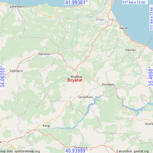
Boyabat GPS coordinates[2]
41° 28' 8.004" North, 34° 46' 0.012" East
| Map corner | latitude | longitude |
|---|---|---|
| Upper-left | 41.99361°, | 34.06355° |
| Center: | 41.46889°, | 34.76667° |
| Lower-right: | 40.93989°, | 35.4698° |
| Map W x H: | 117.2×117.2 km | = 72.8×72.8mi |
| max Lat: | 42.02683° ⇑2.8% North |
| Boyabat: | 41.46889° |
| min Lat: | ⇓97.2% South 35.9025° |
| min Long | Boyabat | max Long |
| 25.90902° | 34.76667° | 44.60099° |
| W 44.7%⇐ | ⇒55.3% E |
Elevation
Elevation of Boyabat is 314 m = 1030 ft, and this is 403.4 m = 1323 ft below average elevation for this country.
| Max E: |
2682 m = 8799 ft | 69.6% |
| Avg. | 717.4 m = 2354 ft | |
| Boyabat | 314 m = 1030 ft | |
Min E: |
0 m = 0 ft | 30.4% |
See also: Turkey elevation on elevation.city.
Geographical zone
Boyabat is located in North temperate zone (between Tropic of Cancer and the Arctic Circle). Distance of this Northern Tropic circle is 2005 km =1245.8 mi to South.| Distance of | km | miles | from Boyabat |
|---|---|---|---|
| North Pole | 5396.2 | 3353 | to North |
| Arctic Circle | 2790.3 | 1733.8 | to North |
| Tropic Cancer | 2005 | 1245.8 | to South |
| Equator | 4610.9 | 2865.1 | to South |


Nearby cities:
15 places around Boyabat: (largest is in red/bold)
• Beşpınar
52.6 km =32.7 mi,  134°
134°
• Dikmen
46.2 km =28.7 mi,  64°
64°
• Durağan
24.7 km =15.3 mi,  103°
103°
• Erfelek
47.3 km =29.4 mi,  15°
15°
• Gerze
51.9 km =32.2 mi,  44°
44°
• Hacıhamza
51.3 km =31.9 mi,  211°
211°
• Hanönü
30.5 km =19 mi,  305°
305°
• Kabalı
49.2 km =30.6 mi,  29°
29°
• Kargı
44 km =27.3 mi, 212°
• Kâmil
40.6 km =25.2 mi,  180°
180°
• Mezraa
42 km =26.1 mi,  135°
135°
• Saraydüzü
17 km =10.6 mi,  156°
156°
• Taşköprü
46.2 km =28.7 mi,  275°
275°
• Yenikonak
47 km =29.2 mi,  343°
343°
• Çerçiler
40 km =24.9 mi, 101°
Sources, notices
• [Note1] Compared only with cities in Turkey existing in our database
• [Src1] Map data: © OpenStreetMap contributors (CC-BY-SA)
• [Src2] Other city data from geonames.org with taken over terms of usage.
• [Src3] Geographical zone / Annual Mean Temperature by Robert A. Rohde @ Wikipedia
