Erfelek geodata
Erfelek (Sinop) is a seat of a second-order administrative division; located in Turkey in Europe/Istanbul (GMT+3) time zone. With population of 3,596 people, there are 814 cities with bigger population in this country. Compared to other cities in Turkey, 99.4% of cities are located further ↓South; 54.6% of cities are located further →East and 72.1% of cities have higher elevation than Erfelek. Note1


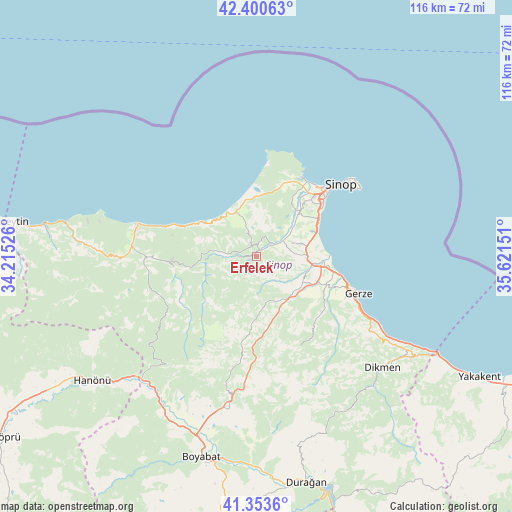
Erfelek GPS coordinates[2]
41° 52' 45.336" North, 34° 55' 6.168" East
| Map corner | latitude | longitude |
|---|---|---|
| Upper-left | 42.40063°, | 34.21526° |
| Center: | 41.87926°, | 34.91838° |
| Lower-right: | 41.3536°, | 35.62151° |
| Map W x H: | 116.4×116.4 km | = 72.3×72.3mi |
| max Lat: | 42.02683° ⇑0.6% North |
| Erfelek: | 41.87926° |
| min Lat: | ⇓99.4% South 35.9025° |
| min Long | Erfelek | max Long |
| 25.90902° | 34.91838° | 44.60099° |
| W 45.4%⇐ | ⇒54.6% E |
Elevation
Elevation of Erfelek is 233 m = 764 ft, and this is 484.4 m = 1589 ft below average elevation for this country.
| Max E: |
2682 m = 8799 ft | 72.1% |
| Avg. | 717.4 m = 2354 ft | |
| Erfelek | 233 m = 764 ft | |
Min E: |
0 m = 0 ft | 27.9% |
See also: Turkey elevation on elevation.city.
Geographical zone
Erfelek is located in North temperate zone (between Tropic of Cancer and the Arctic Circle). Distance of this Northern Tropic circle is 2050.6 km =1274.2 mi to South.| Distance of | km | miles | from Erfelek |
|---|---|---|---|
| North Pole | 5350.5 | 3324.6 | to North |
| Arctic Circle | 2744.6 | 1705.4 | to North |
| Tropic Cancer | 2050.6 | 1274.2 | to South |
| Equator | 4656.5 | 2893.4 | to South |


Nearby cities:
15 places around Erfelek: (largest is in red/bold)
• Ayancık
28.4 km =17.6 mi,  284°
284°
• Boyabat
47.3 km =29.4 mi,  195°
195°
• Dikmen
38.5 km =23.9 mi,  131°
131°
• Durağan
52.8 km =32.8 mi,  167°
167°
• Gerze
24.9 km =15.5 mi,  109°
109°
• Güzelkent
44 km =27.3 mi, 280°
• Hanönü
46.8 km =29.1 mi,  233°
233°
• Kabalı
12.3 km =7.6 mi,  104°
104°
• Saraydüzü
61.5 km =38.2 mi,  185°
185°
• Sinop
26 km =16.2 mi,  50°
50°
• Türkeli
48.6 km =30.2 mi, 279°
• Yakakent
57.6 km =35.8 mi,  118°
118°
• Yenikonak
26.1 km =16.2 mi,  268°
268°
• Çatalzeytin
58.7 km =36.5 mi, 278°
• Çerçiler
60 km =37.3 mi,  153°
153°
Sources, notices
• [Note1] Compared only with cities in Turkey existing in our database
• [Src1] Map data: © OpenStreetMap contributors (CC-BY-SA)
• [Src2] Other city data from geonames.org with taken over terms of usage.
• [Src3] Geographical zone / Annual Mean Temperature by Robert A. Rohde @ Wikipedia
