Kabalı geodata
Kabalı (Sinop) is a seat of a third-order administrative division; located in Turkey in Europe/Istanbul (GMT+3) time zone. In our database, there are 1323 cities with bigger population. Compared to other cities in Turkey, 99.3% of cities are located further ↓South; 54% of cities are located further →East and 83.9% of cities have higher elevation than Kabalı. Note1


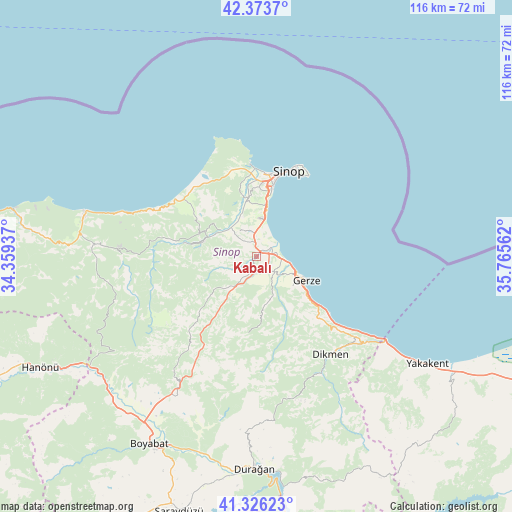
Kabalı GPS coordinates[2]
41° 51' 7.596" North, 35° 3' 44.964" East
| Map corner | latitude | longitude |
|---|---|---|
| Upper-left | 42.3737°, | 34.35937° |
| Center: | 41.85211°, | 35.06249° |
| Lower-right: | 41.32623°, | 35.76562° |
| Map W x H: | 116.5×116.5 km | = 72.4×72.4mi |
| max Lat: | 42.02683° ⇑0.7% North |
| Kabalı: | 41.85211° |
| min Lat: | ⇓99.3% South 35.9025° |
| min Long | Kabalı | max Long |
| 25.90902° | 35.06249° | 44.60099° |
| W 46%⇐ | ⇒54% E |
Elevation
Elevation of Kabalı is 81 m = 266 ft, and this is 636.4 m = 2088 ft below average elevation for this country.
| Max E: |
2682 m = 8799 ft | 83.9% |
| Avg. | 717.4 m = 2354 ft | |
| Kabalı | 81 m = 266 ft | |
Min E: |
0 m = 0 ft | 16.1% |
See also: Turkey elevation on elevation.city.
Geographical zone
Kabalı is located in North temperate zone (between Tropic of Cancer and the Arctic Circle). Distance of this Northern Tropic circle is 2047.6 km =1272.3 mi to South.| Distance of | km | miles | from Kabalı |
|---|---|---|---|
| North Pole | 5353.5 | 3326.5 | to North |
| Arctic Circle | 2747.7 | 1707.3 | to North |
| Tropic Cancer | 2047.6 | 1272.3 | to South |
| Equator | 4653.5 | 2891.5 | to South |


Nearby cities:
15 places around Kabalı: (largest is in red/bold)
• Alaçam
52.2 km =32.4 mi,  121°
121°
• Ayancık
40.7 km =25.3 mi,  284°
284°
• Boyabat
49.2 km =30.6 mi,  209°
209°
• Dikmen
28.1 km =17.5 mi,  142°
142°
• Durağan
48.5 km =30.1 mi,  180°
180°
• Erfelek
12.3 km =7.6 mi, 284°
• Gerze
12.7 km =7.9 mi, 115°
• Güzelkent
56.3 km =35 mi, 280°
• Hanönü
55.4 km =34.4 mi,  243°
243°
• Saraydüzü
60.9 km =37.8 mi,  197°
197°
• Sinop
21.1 km =13.1 mi,  23°
23°
• Türkeli
60.8 km =37.8 mi, 280°
• Yakakent
45.8 km =28.5 mi, 122°
• Yenikonak
38.1 km =23.7 mi,  273°
273°
• Çerçiler
52.9 km =32.9 mi,  164°
164°
Sources, notices
• [Note1] Compared only with cities in Turkey existing in our database
• [Src1] Map data: © OpenStreetMap contributors (CC-BY-SA)
• [Src2] Other city data from geonames.org with taken over terms of usage.
• [Src3] Geographical zone / Annual Mean Temperature by Robert A. Rohde @ Wikipedia
