Durağan geodata
Durağan (Sinop) is a seat of a second-order administrative division; located in Turkey in Europe/Istanbul (GMT+3) time zone. With population of 11,626 people, there are 461 cities with bigger population in this country. Compared to other cities in Turkey, 96.6% of cities are located further ↓South; 54.1% of cities are located further →East and 72.8% of cities have higher elevation than Durağan. Note1


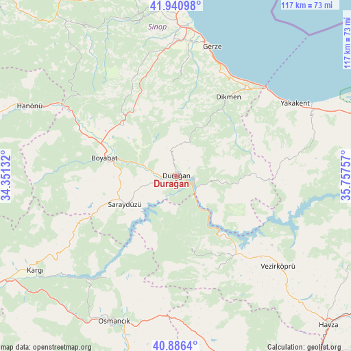
Durağan GPS coordinates[2]
41° 24' 56.988" North, 35° 3' 15.984" East
| Map corner | latitude | longitude |
|---|---|---|
| Upper-left | 41.94098°, | 34.35132° |
| Center: | 41.41583°, | 35.05444° |
| Lower-right: | 40.8864°, | 35.75757° |
| Map W x H: | 117.3×117.3 km | = 72.9×72.9mi |
| max Lat: | 42.02683° ⇑3.4% North |
| Durağan: | 41.41583° |
| min Lat: | ⇓96.6% South 35.9025° |
| min Long | Durağan | max Long |
| 25.90902° | 35.05444° | 44.60099° |
| W 45.9%⇐ | ⇒54.1% E |
Elevation
Elevation of Durağan is 218 m = 715 ft, and this is 499.4 m = 1638 ft below average elevation for this country.
| Max E: |
2682 m = 8799 ft | 72.8% |
| Avg. | 717.4 m = 2354 ft | |
| Durağan | 218 m = 715 ft | |
Min E: |
0 m = 0 ft | 27.2% |
See also: Turkey elevation on elevation.city.
Geographical zone
Durağan is located in North temperate zone (between Tropic of Cancer and the Arctic Circle). Distance of this Northern Tropic circle is 1999.1 km =1242.2 mi to South.| Distance of | km | miles | from Durağan |
|---|---|---|---|
| North Pole | 5402.1 | 3356.7 | to North |
| Arctic Circle | 2796.2 | 1737.5 | to North |
| Tropic Cancer | 1999.1 | 1242.2 | to South |
| Equator | 4605 | 2861.4 | to South |


Nearby cities:
15 places around Durağan: (largest is in red/bold)
• Alaçam
49.9 km =31 mi,  65°
65°
• Beşpınar
33.7 km =20.9 mi,  156°
156°
• Boyabat
24.7 km =15.3 mi,  283°
283°
• Dikmen
31.5 km =19.6 mi,  34°
34°
• Erfelek
52.8 km =32.8 mi,  347°
347°
• Gerze
44.8 km =27.8 mi,  15°
15°
• Kabalı
48.5 km =30.1 mi,  0°
0°
• Kâmil
42.4 km =26.3 mi,  215°
215°
• Mezraa
24.8 km =15.4 mi,  167°
167°
• Osmancık
53 km =32.9 mi,  203°
203°
• Saraycık
52 km =32.3 mi, 174°
• Saraydüzü
19.8 km =12.3 mi,  240°
240°
• Vezirköprü
45.1 km =28 mi,  132°
132°
• Yakakent
46.3 km =28.8 mi,  58°
58°
• Çerçiler
15.4 km =9.6 mi,  98°
98°
Sources, notices
• [Note1] Compared only with cities in Turkey existing in our database
• [Src1] Map data: © OpenStreetMap contributors (CC-BY-SA)
• [Src2] Other city data from geonames.org with taken over terms of usage.
• [Src3] Geographical zone / Annual Mean Temperature by Robert A. Rohde @ Wikipedia
