Hanönü geodata
Hanönü (Kastamonu) is a seat of a second-order administrative division; located in Turkey in Europe/Istanbul (GMT+3) time zone. With population of 2,445 people, there are 907 cities with bigger population in this country. Compared to other cities in Turkey, 98.2% of cities are located further ↓South; 56.7% of cities are located further →East and 64.5% of cities have higher elevation than Hanönü. Note1


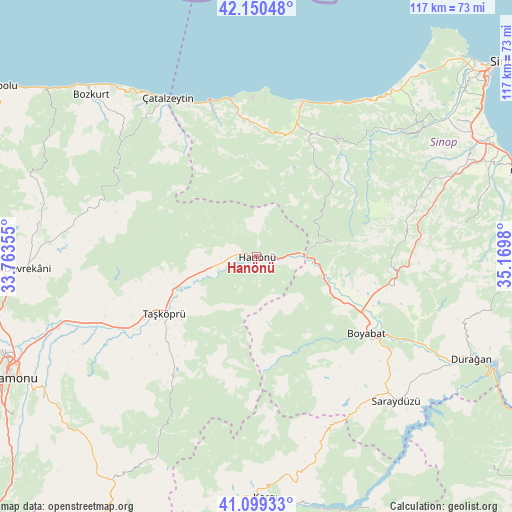
Hanönü GPS coordinates[2]
41° 37' 37.38" North, 34° 28' 0.012" East
| Map corner | latitude | longitude |
|---|---|---|
| Upper-left | 42.15048°, | 33.76355° |
| Center: | 41.62705°, | 34.46667° |
| Lower-right: | 41.09933°, | 35.1698° |
| Map W x H: | 116.9×116.9 km | = 72.6×72.6mi |
| max Lat: | 42.02683° ⇑1.8% North |
| Hanönü: | 41.62705° |
| min Lat: | ⇓98.2% South 35.9025° |
| min Long | Hanönü | max Long |
| 25.90902° | 34.46667° | 44.60099° |
| W 43.3%⇐ | ⇒56.7% E |
Elevation
Elevation of Hanönü is 426 m = 1398 ft, and this is 291.4 m = 956 ft below average elevation for this country.
| Max E: |
2682 m = 8799 ft | 64.5% |
| Avg. | 717.4 m = 2354 ft | |
| Hanönü | 426 m = 1398 ft | |
Min E: |
0 m = 0 ft | 35.5% |
See also: Turkey elevation on elevation.city.
Geographical zone
Hanönü is located in North temperate zone (between Tropic of Cancer and the Arctic Circle). Distance of this Northern Tropic circle is 2022.6 km =1256.8 mi to South.| Distance of | km | miles | from Hanönü |
|---|---|---|---|
| North Pole | 5378.6 | 3342.1 | to North |
| Arctic Circle | 2772.7 | 1722.9 | to North |
| Tropic Cancer | 2022.6 | 1256.8 | to South |
| Equator | 4628.5 | 2876 | to South |


Nearby cities:
15 places around Hanönü: (largest is in red/bold)
• Abana
54.4 km =33.8 mi,  315°
315°
• Ayancık
36.7 km =22.8 mi,  15°
15°
• Boyabat
30.5 km =19 mi,  125°
125°
• Bozkurt
52.7 km =32.7 mi,  314°
314°
• Devrekani
52.2 km =32.4 mi,  267°
267°
• Durağan
54.3 km =33.7 mi,  115°
115°
• Erfelek
46.8 km =29.1 mi,  53°
53°
• Güzelkent
36.2 km =22.5 mi,  350°
350°
• Kabalı
55.4 km =34.4 mi,  63°
63°
• Kargı
54.9 km =34.1 mi,  178°
178°
• Saraydüzü
45.9 km =28.5 mi,  136°
136°
• Taşköprü
24.7 km =15.3 mi,  238°
238°
• Türkeli
37.2 km =23.1 mi,  343°
343°
• Yenikonak
29.6 km =18.4 mi, 22°
• Çatalzeytin
41.8 km =26 mi,  330°
330°
Sources, notices
• [Note1] Compared only with cities in Turkey existing in our database
• [Src1] Map data: © OpenStreetMap contributors (CC-BY-SA)
• [Src2] Other city data from geonames.org with taken over terms of usage.
• [Src3] Geographical zone / Annual Mean Temperature by Robert A. Rohde @ Wikipedia
