Iğdır geodata
Iğdır is a seat of a first-order administrative division; located in Turkey in Europe/Istanbul (GMT+3) time zone. With population of 75,721 people, there are 119 cities with bigger population in this country. Compared to other cities in Turkey, 68.1% of cities are located further ↓South; 99.5% of cities are located further ←West and 58.7% of cities have lower elevation than Iğdır. Note1


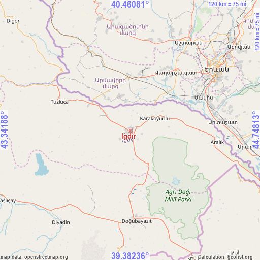
Iğdır GPS coordinates[2]
39° 55' 25.356" North, 44° 2' 42" East
| Map corner | latitude | longitude |
|---|---|---|
| Upper-left | 40.46081°, | 43.34188° |
| Center: | 39.92371°, | 44.045° |
| Lower-right: | 39.38236°, | 44.74813° |
| Map W x H: | 119.9×119.9 km | = 74.5×74.5mi |
| max Lat: | 42.02683° ⇑31.9% North |
| Iğdır: | 39.92371° |
| min Lat: | ⇓68.1% South 35.9025° |
| min Long | Iğdır | max Long |
| 25.90902° | 44.045° | 44.60099° |
| W 99.5%⇐ | ⇒0.5% E |
Elevation
Elevation of Iğdır is 860 m = 2822 ft, and this is 142.6 m = 468 ft above average elevation for this country.
| Max E: |
2682 m = 8799 ft | 41.3% |
| Iğdır | 860 m 2822 ft | |
| Avg. | 717.4 m = 2354 ft | |
Min E: |
0 m = 0 ft | 58.7% |
See also: Iğdır elevation on elevation.city.
Geographical zone
Iğdır is located in North temperate zone (between Tropic of Cancer and the Arctic Circle). Distance of this Northern Tropic circle is 1833.2 km =1139.1 mi to South.| Distance of | km | miles | from Iğdır |
|---|---|---|---|
| North Pole | 5568 | 3459.8 | to North |
| Arctic Circle | 2962.1 | 1840.6 | to North |
| Tropic Cancer | 1833.2 | 1139.1 | to South |
| Equator | 4439.1 | 2758.3 | to South |


Nearby cities:
15 places around Iğdır: (largest is in red/bold)
• Aralık
40.8 km =25.4 mi,  97°
97°
• Ağrı
87.8 km =54.6 mi,  255°
255°
• Cumaçay
73.2 km =45.5 mi,  269°
269°
• Digor
73.2 km =45.5 mi,  312°
312°
• Diyadin
53.3 km =33.1 mi,  216°
216°
• Doğubayazıt
42 km =26.1 mi,  175°
175°
• Gaziler
53.5 km =33.2 mi,  289°
289°
• Karakoyunlu
35.9 km =22.3 mi, 260°
• Kağızman
81.7 km =50.8 mi, 288°
• Murat
74.2 km =46.1 mi,  247°
247°
• Suluçem
32.2 km =20 mi, 217°
• Taşburun
16.7 km =10.4 mi,  65°
65°
• Taşlıçay
66.4 km =41.3 mi,  240°
240°
• Tuzluca
35.8 km =22.2 mi, 290°
• Çaldıran
87.5 km =54.4 mi,  187°
187°
Sources, notices
• [Note1] Compared only with cities in Turkey existing in our database
• [Src1] Map data: © OpenStreetMap contributors (CC-BY-SA)
• [Src2] Other city data from geonames.org with taken over terms of usage.
• [Src3] Geographical zone / Annual Mean Temperature by Robert A. Rohde @ Wikipedia
