Alaçam geodata
Alaçam (Samsun) is a seat of a second-order administrative division; located in Turkey in Europe/Istanbul (GMT+3) time zone. In our database, there are 1323 cities with bigger population. Compared to other cities in Turkey, 98.1% of cities are located further ↓South; 51.7% of cities are located further →East and 88.8% of cities have higher elevation than Alaçam. Note1


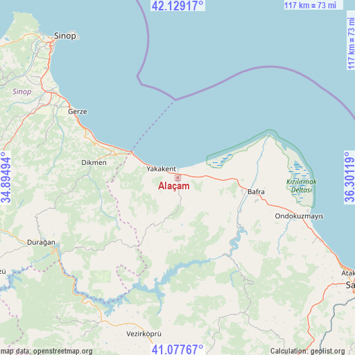
Alaçam GPS coordinates[2]
41° 36' 20.016" North, 35° 35' 53.016" East
| Map corner | latitude | longitude |
|---|---|---|
| Upper-left | 42.12917°, | 34.89494° |
| Center: | 41.60556°, | 35.59806° |
| Lower-right: | 41.07767°, | 36.30119° |
| Map W x H: | 116.9×116.9 km | = 72.6×72.6mi |
| max Lat: | 42.02683° ⇑1.9% North |
| Alaçam: | 41.60556° |
| min Lat: | ⇓98.1% South 35.9025° |
| min Long | Alaçam | max Long |
| 25.90902° | 35.59806° | 44.60099° |
| W 48.3%⇐ | ⇒51.7% E |
Elevation
Elevation of Alaçam is 45 m = 148 ft, and this is 672.4 m = 2206 ft below average elevation for this country.
| Max E: |
2682 m = 8799 ft | 88.8% |
| Avg. | 717.4 m = 2354 ft | |
| Alaçam | 45 m = 148 ft | |
Min E: |
0 m = 0 ft | 11.2% |
See also: Turkey elevation on elevation.city.
Geographical zone
Alaçam is located in North temperate zone (between Tropic of Cancer and the Arctic Circle). Distance of this Northern Tropic circle is 2020.2 km =1255.3 mi to South.| Distance of | km | miles | from Alaçam |
|---|---|---|---|
| North Pole | 5381 | 3343.6 | to North |
| Arctic Circle | 2775.1 | 1724.4 | to North |
| Tropic Cancer | 2020.2 | 1255.3 | to South |
| Equator | 4626.1 | 2874.5 | to South |


Nearby cities:
15 places around Alaçam: (largest is in red/bold)
• Bafra
26 km =16.2 mi,  99°
99°
• Boğazkaya
28.3 km =17.6 mi,  127°
127°
• Dikmen
28 km =17.4 mi,  280°
280°
• Durağan
49.9 km =31 mi,  245°
245°
• Gerze
39.6 km =24.6 mi,  303°
303°
• Kabalı
52.2 km =32.4 mi, 301°
• Kolay
26.8 km =16.7 mi,  140°
140°
• Mezraa
60.6 km =37.7 mi,  221°
221°
• Ondokuzmayıs
40.9 km =25.4 mi,  106°
106°
• Sinop
59.1 km =36.7 mi,  322°
322°
• Taflan
49.3 km =30.6 mi,  116°
116°
• Vezirköprü
52.7 km =32.7 mi,  193°
193°
• Yakakent
6.5 km =4 mi, 297°
• Çakıralan
50.5 km =31.4 mi,  164°
164°
• Çerçiler
38.2 km =23.7 mi,  232°
232°
Sources, notices
• [Note1] Compared only with cities in Turkey existing in our database
• [Src1] Map data: © OpenStreetMap contributors (CC-BY-SA)
• [Src2] Other city data from geonames.org with taken over terms of usage.
• [Src3] Geographical zone / Annual Mean Temperature by Robert A. Rohde @ Wikipedia
