Yakakent geodata
Yakakent (Samsun) is a seat of a second-order administrative division; located in Turkey in Europe/Istanbul (GMT+3) time zone. With population of 5,086 people, there are 719 cities with bigger population in this country. Compared to other cities in Turkey, 98.3% of cities are located further ↓South; 51.9% of cities are located further →East and 96.2% of cities have higher elevation than Yakakent. Note1


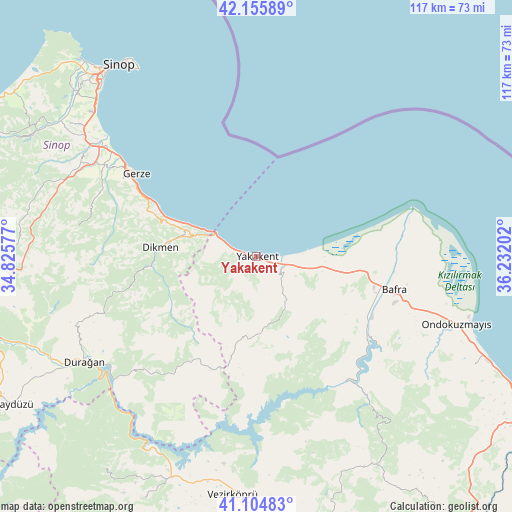
Yakakent GPS coordinates[2]
41° 37' 57" North, 35° 31' 44.004" East
| Map corner | latitude | longitude |
|---|---|---|
| Upper-left | 42.15589°, | 34.82577° |
| Center: | 41.6325°, | 35.52889° |
| Lower-right: | 41.10483°, | 36.23202° |
| Map W x H: | 116.9×116.9 km | = 72.6×72.6mi |
| max Lat: | 42.02683° ⇑1.7% North |
| Yakakent: | 41.6325° |
| min Lat: | ⇓98.3% South 35.9025° |
| min Long | Yakakent | max Long |
| 25.90902° | 35.52889° | 44.60099° |
| W 48.1%⇐ | ⇒51.9% E |
Elevation
Elevation of Yakakent is 13 m = 43 ft, and this is 704.4 m = 2311 ft below average elevation for this country.
| Max E: |
2682 m = 8799 ft | 96.2% |
| Avg. | 717.4 m = 2354 ft | |
| Yakakent | 13 m = 43 ft | |
Min E: |
0 m = 0 ft | 3.8% |
See also: Turkey elevation on elevation.city.
Geographical zone
Yakakent is located in North temperate zone (between Tropic of Cancer and the Arctic Circle). Distance of this Northern Tropic circle is 2023.2 km =1257.2 mi to South.| Distance of | km | miles | from Yakakent |
|---|---|---|---|
| North Pole | 5378 | 3341.7 | to North |
| Arctic Circle | 2772.1 | 1722.5 | to North |
| Tropic Cancer | 2023.2 | 1257.2 | to South |
| Equator | 4629.1 | 2876.4 | to South |


Nearby cities:
15 places around Yakakent: (largest is in red/bold)
• Alaçam
6.5 km =4 mi,  117°
117°
• Bafra
32.2 km =20 mi,  102°
102°
• Boğazkaya
34.7 km =21.6 mi,  125°
125°
• Dikmen
21.9 km =13.6 mi,  275°
275°
• Durağan
46.3 km =28.8 mi,  238°
238°
• Erfelek
57.6 km =35.8 mi,  298°
298°
• Gerze
33.2 km =20.6 mi, 304°
• Kabalı
45.8 km =28.5 mi, 302°
• Kolay
32.9 km =20.4 mi,  136°
136°
• Ondokuzmayıs
47.2 km =29.3 mi,  108°
108°
• Sinop
53.3 km =33.1 mi,  325°
325°
• Taflan
55.8 km =34.7 mi, 116°
• Vezirköprü
54.7 km =34 mi,  186°
186°
• Çakıralan
55.1 km =34.2 mi,  159°
159°
• Çerçiler
35.9 km =22.3 mi,  222°
222°
Sources, notices
• [Note1] Compared only with cities in Turkey existing in our database
• [Src1] Map data: © OpenStreetMap contributors (CC-BY-SA)
• [Src2] Other city data from geonames.org with taken over terms of usage.
• [Src3] Geographical zone / Annual Mean Temperature by Robert A. Rohde @ Wikipedia
