Njombe geodata
Njombe is a seat of a first-order administrative division; located in Tanzania in Africa/Dar_es_Salaam (GMT+3) time zone. With population of 46,724 people, there are 31 cities with bigger population in this country. Compared to other cities in Tanzania, 85.3% of cities are located further ↑North; 55.2% of cities are located further →East and 93.7% of cities have lower elevation than Njombe. Note1


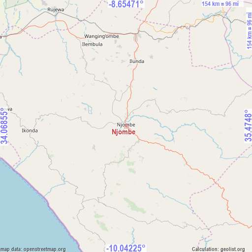
Njombe GPS coordinates[2]
9° 20' 57.012" South, 34° 46' 18.012" East
| Map corner | latitude | longitude |
|---|---|---|
| Upper-left | -8.65471°, | 34.06855° |
| Center: | -9.34917°, | 34.77167° |
| Lower-right: | -10.04225°, | 35.4748° |
| Map W x H: | 154.3×154.3 km | = 95.9×95.9mi |
| max Lat: | -1.14389° ⇑85.3% North |
| Njombe: | -9.34917° |
| min Lat: | ⇓14.7% South -11.36667° |
| min Long | Njombe | max Long |
| 29.62667° | 34.77167° | 40.33333° |
| W 44.8%⇐ | ⇒55.2% E |
Elevation
Elevation of Njombe is 1676 m = 5499 ft, and this is 733.2 m = 2406 ft above average elevation for this country.
| Max E: |
2377 m = 7799 ft | 6.3% |
| Njombe | 1676 m 5499 ft | |
| Avg. | 942.8 m = 3093 ft | |
Min E: |
0 m = 0 ft | 93.7% |
See also: Njombe elevation on elevation.city.
Geographical zone
Njombe is located in South Torrid zone (between Equator and Tropic of Capricorn). Distance of Equator is 1039.5 km =645.9 mi to North.| Distance of | km | miles | from Njombe |
|---|---|---|---|
| Equator | 1039.5 | 645.9 | to North |
| Tropic Capricorn | 1566.4 | 973.3 | to South |
| Antarctic Circle | 6361.6 | 3952.9 | to South |
| South Pole | 8967.5 | 5572.1 | to South |


Nearby cities:
15 places around Njombe: (largest is in red/bold)
• Chimala
98.7 km =61.3 mi,  303°
303°
• Ilembula
54.1 km =33.6 mi,  337°
337°
• Ipinda
96.8 km =60.1 mi,  261°
261°
• Kandete
108.9 km =67.7 mi,  281°
281°
• Kyela
104.4 km =64.9 mi, 255°
• Mahanje
89.5 km =55.6 mi,  136°
136°
• Makumbako
55.9 km =34.7 mi,  6°
6°
• Makungu
88.6 km =55.1 mi,  39°
39°
• Malangali
87.4 km =54.3 mi, 5°
• Masoko
112.1 km =69.7 mi,  270°
270°
• Matamba
97.3 km =60.5 mi,  294°
294°
• Mlangali
55.8 km =34.7 mi,  210°
210°
• Mtwango
37.1 km =23.1 mi,  4°
4°
• Mwaya
92.8 km =57.7 mi, 256°
• Rujewa
83.8 km =52.1 mi,  329°
329°
Sources, notices
• [Note1] Compared only with cities in Tanzania existing in our database
• [Src1] Map data: © OpenStreetMap contributors (CC-BY-SA)
• [Src2] Other city data from geonames.org with taken over terms of usage.
• [Src3] Geographical zone / Annual Mean Temperature by Robert A. Rohde @ Wikipedia
