Mtwango geodata
Mtwango (Njombe) is a populated place; located in Tanzania in Africa/Dar_es_Salaam (GMT+3) time zone. With population of 19,040 people, there are 138 cities with bigger population in this country. Compared to other cities in Tanzania, 82.2% of cities are located further ↑North; 54.9% of cities are located further →East and 96.5% of cities have lower elevation than Mtwango. Note1


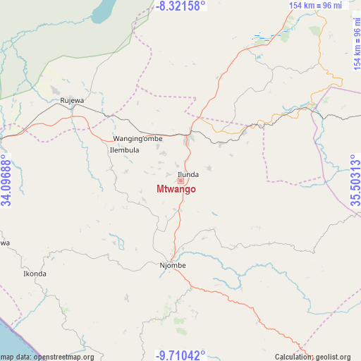
Mtwango GPS coordinates[2]
9° 1' 0.012" South, 34° 48' 0" East
| Map corner | latitude | longitude |
|---|---|---|
| Upper-left | -8.32158°, | 34.09688° |
| Center: | -9.01667°, | 34.8° |
| Lower-right: | -9.71042°, | 35.50313° |
| Map W x H: | 154.4×154.4 km | = 95.9×95.9mi |
| max Lat: | -1.14389° ⇑82.2% North |
| Mtwango: | -9.01667° |
| min Lat: | ⇓17.8% South -11.36667° |
| min Long | Mtwango | max Long |
| 29.62667° | 34.8° | 40.33333° |
| W 45.1%⇐ | ⇒54.9% E |
Elevation
Elevation of Mtwango is 1767 m = 5797 ft, and this is 824.2 m = 2704 ft above average elevation for this country.
| Max E: |
2377 m = 7799 ft | 3.5% |
| Mtwango | 1767 m 5797 ft | |
| Avg. | 942.8 m = 3093 ft | |
Min E: |
0 m = 0 ft | 96.5% |
See also: Tanzania elevation on elevation.city.
Geographical zone
Mtwango is located in South Torrid zone (between Equator and Tropic of Capricorn). Distance of Equator is 1002.6 km =623 mi to North.| Distance of | km | miles | from Mtwango |
|---|---|---|---|
| Equator | 1002.6 | 623 | to North |
| Tropic Capricorn | 1603.4 | 996.3 | to South |
| Antarctic Circle | 6398.6 | 3975.9 | to South |
| South Pole | 9004.5 | 5595.1 | to South |


Nearby cities:
15 places around Mtwango: (largest is in red/bold)
• Chimala
87.1 km =54.1 mi,  281°
281°
• Dunda
116.9 km =72.6 mi,  328°
328°
• Igurusi
106 km =65.9 mi, 280°
• Ilembula
27.1 km =16.8 mi,  298°
298°
• Ipinda
111.6 km =69.3 mi,  242°
242°
• Kandete
110.8 km =68.8 mi,  262°
262°
• Makumbako
18.9 km =11.7 mi,  11°
11°
• Makungu
61.7 km =38.3 mi,  59°
59°
• Malangali
50.3 km =31.3 mi, 6°
• Matamba
91.6 km =56.9 mi,  272°
272°
• Mlangali
90.7 km =56.4 mi,  200°
200°
• Mlimba
114.2 km =71 mi,  77°
77°
• Mwaya
110.5 km =68.7 mi, 237°
• Njombe
37.1 km =23.1 mi,  184°
184°
• Rujewa
57.8 km =35.9 mi,  307°
307°
Sources, notices
• [Note1] Compared only with cities in Tanzania existing in our database
• [Src1] Map data: © OpenStreetMap contributors (CC-BY-SA)
• [Src2] Other city data from geonames.org with taken over terms of usage.
• [Src3] Geographical zone / Annual Mean Temperature by Robert A. Rohde @ Wikipedia
