Matiri geodata
Matiri (Ruvuma) is a populated place; located in Tanzania in Africa/Dar_es_Salaam (GMT+3) time zone. With population of 18,830 people, there are 141 cities with bigger population in this country. Compared to other cities in Tanzania, 94.8% of cities are located further ↑North; 52.8% of cities are located further →East and 73.1% of cities have lower elevation than Matiri. Note1


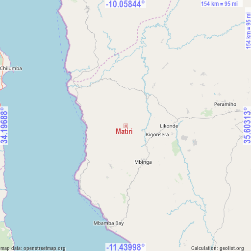
Matiri GPS coordinates[2]
10° 45' 0" South, 34° 54' 0" East
| Map corner | latitude | longitude |
|---|---|---|
| Upper-left | -10.05844°, | 34.19688° |
| Center: | -10.75°, | 34.9° |
| Lower-right: | -11.43998°, | 35.60313° |
| Map W x H: | 153.6×153.6 km | = 95.4×95.4mi |
| max Lat: | -1.14389° ⇑94.8% North |
| Matiri: | -10.75° |
| min Lat: | ⇓5.2% South -11.36667° |
| min Long | Matiri | max Long |
| 29.62667° | 34.9° | 40.33333° |
| W 47.2%⇐ | ⇒52.8% E |
Elevation
Elevation of Matiri is 1324 m = 4344 ft, and this is 381.2 m = 1251 ft above average elevation for this country.
| Max E: |
2377 m = 7799 ft | 26.9% |
| Matiri | 1324 m 4344 ft | |
| Avg. | 942.8 m = 3093 ft | |
Min E: |
0 m = 0 ft | 73.1% |
See also: Tanzania elevation on elevation.city.
Geographical zone
Matiri is located in South Torrid zone (between Equator and Tropic of Capricorn). Distance of Equator is 1195.3 km =742.7 mi to North.| Distance of | km | miles | from Matiri |
|---|---|---|---|
| Equator | 1195.3 | 742.7 | to North |
| Tropic Capricorn | 1410.6 | 876.5 | to South |
| Antarctic Circle | 6205.9 | 3856.2 | to South |
| South Pole | 8811.8 | 5475.4 | to South |


Nearby cities:
15 places around Matiri: (largest is in red/bold)
• Ipinda
178.4 km =110.9 mi,  322°
322°
• Kigonsera
17.3 km =10.7 mi,  108°
108°
• Kyela
173.3 km =107.7 mi, 318°
• Liuli
47.1 km =29.3 mi,  218°
218°
• Mahanje
102.4 km =63.6 mi,  27°
27°
• Manda
46.8 km =29.1 mi,  312°
312°
• Maposeni
57.7 km =35.9 mi,  71°
71°
• Mbamba Bay
61.1 km =38 mi,  193°
193°
• Mbinga
24 km =14.9 mi,  147°
147°
• Mlangali
115.4 km =71.7 mi,  338°
338°
• Mtwango
193 km =119.9 mi,  356°
356°
• Mwaya
169.2 km =105.1 mi, 322°
• Njombe
156.4 km =97.2 mi,  354°
354°
• Songea
82.3 km =51.1 mi,  84°
84°
• Tingi
62.9 km =39.1 mi,  166°
166°
Sources, notices
• [Note1] Compared only with cities in Tanzania existing in our database
• [Src1] Map data: © OpenStreetMap contributors (CC-BY-SA)
• [Src2] Other city data from geonames.org with taken over terms of usage.
• [Src3] Geographical zone / Annual Mean Temperature by Robert A. Rohde @ Wikipedia
