Malangali geodata
Malangali (Iringa) is a populated place; located in Tanzania in Africa/Dar_es_Salaam (GMT+3) time zone. With population of 7,112 people, there are 263 cities with bigger population in this country. Compared to other cities in Tanzania, 76.9% of cities are located further ↑North; 54.2% of cities are located further →East and 78.7% of cities have lower elevation than Malangali. Note1


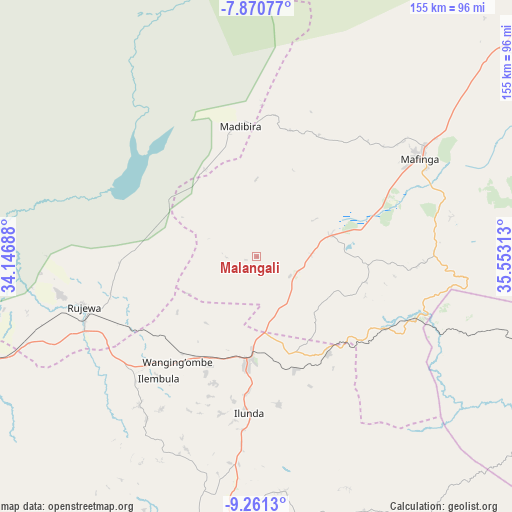
Malangali GPS coordinates[2]
8° 34' 0.012" South, 34° 51' 0" East
| Map corner | latitude | longitude |
|---|---|---|
| Upper-left | -7.87077°, | 34.14688° |
| Center: | -8.56667°, | 34.85° |
| Lower-right: | -9.2613°, | 35.55313° |
| Map W x H: | 154.6×154.6 km | = 96.1×96.1mi |
| max Lat: | -1.14389° ⇑76.9% North |
| Malangali: | -8.56667° |
| min Lat: | ⇓23.1% South -11.36667° |
| min Long | Malangali | max Long |
| 29.62667° | 34.85° | 40.33333° |
| W 45.8%⇐ | ⇒54.2% E |
Elevation
Elevation of Malangali is 1388 m = 4554 ft, and this is 445.2 m = 1461 ft above average elevation for this country.
| Max E: |
2377 m = 7799 ft | 21.3% |
| Malangali | 1388 m 4554 ft | |
| Avg. | 942.8 m = 3093 ft | |
Min E: |
0 m = 0 ft | 78.7% |
See also: Tanzania elevation on elevation.city.
Geographical zone
Malangali is located in South Torrid zone (between Equator and Tropic of Capricorn). Distance of Equator is 952.5 km =591.9 mi to North.| Distance of | km | miles | from Malangali |
|---|---|---|---|
| Equator | 952.5 | 591.9 | to North |
| Tropic Capricorn | 1653.4 | 1027.4 | to South |
| Antarctic Circle | 6448.6 | 4007 | to South |
| South Pole | 9054.5 | 5626.2 | to South |


Nearby cities:
15 places around Malangali: (largest is in red/bold)
• Chimala
96.3 km =59.8 mi,  250°
250°
• Dunda
82.8 km =51.4 mi,  307°
307°
• Igurusi
114.3 km =71 mi, 254°
• Ilembula
47.2 km =29.3 mi,  218°
218°
• Iringa
129.1 km =80.2 mi,  46°
46°
• Kandete
132.3 km =82.2 mi,  240°
240°
• Makumbako
31.6 km =19.6 mi,  183°
183°
• Makungu
51.1 km =31.8 mi,  111°
111°
• Matamba
107.6 km =66.9 mi, 244°
• Mlangali
140.1 km =87.1 mi,  195°
195°
• Mlimba
109.4 km =68 mi,  103°
103°
• Mtwango
50.3 km =31.3 mi,  186°
186°
• Njombe
87.4 km =54.3 mi, 185°
• Rujewa
53.4 km =33.2 mi, 253°
• Ulenje
134.5 km =83.6 mi, 252°
Sources, notices
• [Note1] Compared only with cities in Tanzania existing in our database
• [Src1] Map data: © OpenStreetMap contributors (CC-BY-SA)
• [Src2] Other city data from geonames.org with taken over terms of usage.
• [Src3] Geographical zone / Annual Mean Temperature by Robert A. Rohde @ Wikipedia
