Songea geodata
Songea (Ruvuma) is a seat of a first-order administrative division; located in Tanzania in Africa/Dar_es_Salaam (GMT+3) time zone. With population of 126,449 people, there are 11 cities with bigger population in this country. Compared to other cities in Tanzania, 93.4% of cities are located further ↑North; 53.8% of cities are located further ←West and 52.1% of cities have higher elevation than Songea. Note1


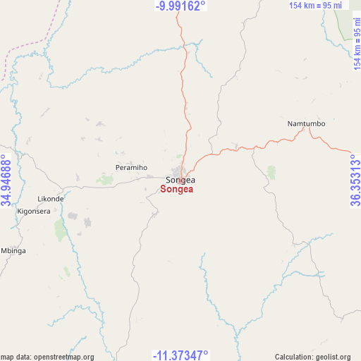
Songea GPS coordinates[2]
10° 40' 59.988" South, 35° 39' 0" East
| Map corner | latitude | longitude |
|---|---|---|
| Upper-left | -9.99162°, | 34.94688° |
| Center: | -10.68333°, | 35.65° |
| Lower-right: | -11.37347°, | 36.35313° |
| Map W x H: | 153.6×153.6 km | = 95.4×95.4mi |
| max Lat: | -1.14389° ⇑93.4% North |
| Songea: | -10.68333° |
| min Lat: | ⇓6.6% South -11.36667° |
| min Long | Songea | max Long |
| 29.62667° | 35.65° | 40.33333° |
| W 53.8%⇐ | ⇒46.2% E |
Elevation
Elevation of Songea is 1113 m = 3652 ft, and this is 170.2 m = 558 ft above average elevation for this country.
| Max E: |
2377 m = 7799 ft | 52.1% |
| Songea | 1113 m 3652 ft | |
| Avg. | 942.8 m = 3093 ft | |
Min E: |
0 m = 0 ft | 47.9% |
See also: Songea elevation on elevation.city.
Geographical zone
Songea is located in South Torrid zone (between Equator and Tropic of Capricorn). Distance of Equator is 1187.9 km =738.1 mi to North.| Distance of | km | miles | from Songea |
|---|---|---|---|
| Equator | 1187.9 | 738.1 | to North |
| Tropic Capricorn | 1418 | 881.1 | to South |
| Antarctic Circle | 6213.3 | 3860.8 | to South |
| South Pole | 8819.2 | 5480 | to South |


Nearby cities:
15 places around Songea: (largest is in red/bold)
• Kigonsera
66.8 km =41.5 mi,  258°
258°
• Liuli
119.6 km =74.3 mi,  248°
248°
• Mahanje
90.3 km =56.1 mi,  337°
337°
• Makungu
220.5 km =137 mi,  349°
349°
• Malinyi
201.7 km =125.3 mi,  15°
15°
• Manda
119.1 km =74 mi,  281°
281°
• Maposeni
29.5 km =18.3 mi,  292°
292°
• Matiri
82.3 km =51.1 mi, 264°
• Mbamba Bay
117.2 km =72.8 mi,  235°
235°
• Mbinga
74.5 km =46.3 mi, 248°
• Mlangali
159.3 km =99 mi,  308°
308°
• Mlimba
210.2 km =130.6 mi,  4°
4°
• Mtwango
207.4 km =128.9 mi,  333°
333°
• Njombe
176.8 km =109.9 mi, 327°
• Tingi
96.1 km =59.7 mi,  224°
224°
Sources, notices
• [Note1] Compared only with cities in Tanzania existing in our database
• [Src1] Map data: © OpenStreetMap contributors (CC-BY-SA)
• [Src2] Other city data from geonames.org with taken over terms of usage.
• [Src3] Geographical zone / Annual Mean Temperature by Robert A. Rohde @ Wikipedia
