Mbamba Bay geodata
Mbamba Bay (Ruvuma) is a populated place; located in Tanzania in Africa/Dar_es_Salaam (GMT+3) time zone. With population of 8,997 people, there are 247 cities with bigger population in this country. Compared to other cities in Tanzania, 99.3% of cities are located further ↑North; 55.9% of cities are located further →East and 73.1% of cities have higher elevation than Mbamba Bay. Note1


Mbamba Bay GPS coordinates[2]
11° 16' 59.988" South, 34° 46' 0.012" East
| Map corner | latitude | longitude |
|---|---|---|
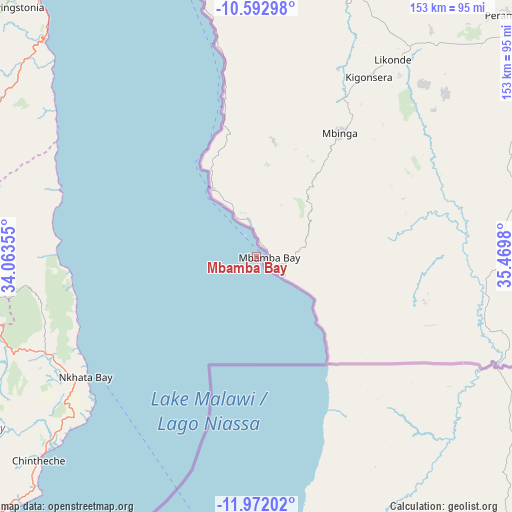
| Upper-left | -10.59298°, | 34.06355° |
| Center: | -11.28333°, | 34.76667° |
| Lower-right: | -11.97202°, | 35.4698° |
| Map W x H: | 153.3×153.3 km | = 95.3×95.3mi |
| max Lat: | -1.14389° ⇑99.3% North |
| Mbamba Bay: | -11.28333° |
| min Lat: | ⇓0.7% South -11.36667° |
| min Long | Mbamba Bay | max Long |
| 29.62667° | 34.76667° | 40.33333° |
| W 44.1%⇐ | ⇒55.9% E |
Elevation
Elevation of Mbamba Bay is 476 m = 1562 ft, and this is 466.8 m = 1531 ft below average elevation for this country.
| Max E: |
2377 m = 7799 ft | 73.1% |
| Avg. | 942.8 m = 3093 ft | |
| Mbamba Bay | 476 m = 1562 ft | |
Min E: |
0 m = 0 ft | 26.9% |
See also: Tanzania elevation on elevation.city.
Geographical zone
Mbamba Bay is located in South Torrid zone (between Equator and Tropic of Capricorn). Distance of Equator is 1254.6 km =779.6 mi to North.| Distance of | km | miles | from Mbamba Bay |
|---|---|---|---|
| Equator | 1254.6 | 779.6 | to North |
| Tropic Capricorn | 1351.3 | 839.7 | to South |
| Antarctic Circle | 6146.6 | 3819.3 | to South |
| South Pole | 8752.5 | 5438.5 | to South |


Nearby cities:
15 places around Mbamba Bay: (largest is in red/bold)
• Ipinda
221.5 km =137.6 mi,  334°
334°
• Kigonsera
62 km =38.5 mi,  29°
29°
• Kyela
214 km =133 mi, 332°
• Liuli
26.6 km =16.5 mi, 326°
• Mahanje
162.4 km =100.9 mi,  22°
22°
• Manda
93 km =57.8 mi,  347°
347°
• Maposeni
104.1 km =64.7 mi,  41°
41°
• Masoko
243.7 km =151.4 mi, 332°
• Matiri
61.1 km =38 mi,  13°
13°
• Mbinga
47.5 km =29.5 mi, 35°
• Mlangali
169 km =105 mi, 350°
• Mwaya
212.4 km =132 mi,  335°
335°
• Njombe
215.1 km =133.7 mi,  0°
0°
• Songea
117.2 km =72.8 mi,  55°
55°
• Tingi
29.1 km =18.1 mi,  93°
93°
Sources, notices
• [Note1] Compared only with cities in Tanzania existing in our database
• [Src1] Map data: © OpenStreetMap contributors (CC-BY-SA)
• [Src2] Other city data from geonames.org with taken over terms of usage.
• [Src3] Geographical zone / Annual Mean Temperature by Robert A. Rohde @ Wikipedia
