Horodenka geodata
Horodenka (Ivano-Frankivsk) is a seat of a second-order administrative division; located in Ukraine in Europe/Kiev (GMT+3) time zone. With population of 9,430 people, there are 378 cities with bigger population in this country. Compared to other cities in Ukraine, 59.6% of cities are located further ↓South; 83.7% of cities are located further →East and 84% of cities have lower elevation than Horodenka. Note1


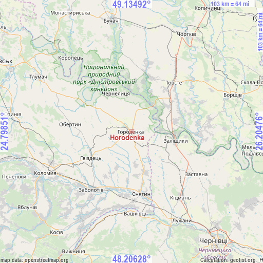
Horodenka GPS coordinates[2]
48° 40' 21.864" North, 25° 30' 5.868" East
| Map corner | latitude | longitude |
|---|---|---|
| Upper-left | 49.13492°, | 24.79851° |
| Center: | 48.67274°, | 25.50163° |
| Lower-right: | 48.20628°, | 26.20476° |
| Map W x H: | 103.3×103.3 km | = 64.2×64.2mi |
| max Lat: | 52.18903° ⇑40.4% North |
| Horodenka: | 48.67274° |
| min Lat: | ⇓59.6% South 44.39214° |
| min Long | Horodenka | max Long |
| 22.20555° | 25.50163° | 40.13222° |
| W 16.3%⇐ | ⇒83.7% E |
Elevation
Elevation of Horodenka is 267 m = 876 ft, and this is 111.2 m = 365 ft above average elevation for this country.
| Max E: |
886 m = 2907 ft | 16% |
| Horodenka | 267 m 876 ft | |
| Avg. | 155.8 m = 511 ft | |
Min E: |
-3 m = -10 ft | 84% |
See also: Ukraine elevation on elevation.city.
Geographical zone
Horodenka is located in North temperate zone (between Tropic of Cancer and the Arctic Circle). Distance of this North polar circle is 1989.3 km =1236.1 mi to North.| Distance of | km | miles | from Horodenka |
|---|---|---|---|
| North Pole | 4595.2 | 2855.3 | to North |
| Arctic Circle | 1989.3 | 1236.1 | to North |
| Tropic Cancer | 2806 | 1743.6 | to South |
| Equator | 5411.9 | 3362.8 | to South |


Nearby cities:
15 places around Horodenka: (largest is in red/bold)
• Chernelytsya
16.5 km =10.3 mi,  340°
340°
• Chernyatyn
4.2 km =2.6 mi,  250°
250°
• Kadubivtsi
22 km =13.7 mi,  116°
116°
• Kostryzhivka
15.7 km =9.8 mi,  97°
97°
• Nyrkiv
17.4 km =10.8 mi,  24°
24°
• Obertyn
24.5 km =15.2 mi,  277°
277°
• Sniatyn
25.6 km =15.9 mi,  168°
168°
• Stetseva
17 km =10.6 mi,  161°
161°
• Tovste
25.4 km =15.8 mi,  40°
40°
• Vashkivtsi
32 km =19.9 mi,  178°
178°
• Verenchanka
22.8 km =14.2 mi,  128°
128°
• Zabolotiv
27.5 km =17.1 mi,  215°
215°
• Zalishchyky
17.7 km =11 mi, 100°
• Zastavna
30.2 km =18.8 mi, 123°
• Zolotyy Potik
28.9 km =18 mi, 335°
Sources, notices
• [Note1] Compared only with cities in Ukraine existing in our database
• [Src1] Map data: © OpenStreetMap contributors (CC-BY-SA)
• [Src2] Other city data from geonames.org with taken over terms of usage.
• [Src3] Geographical zone / Annual Mean Temperature by Robert A. Rohde @ Wikipedia
