Yahotyn geodata
Yahotyn (Kyiv) is a seat of a second-order administrative division; located in Ukraine in Europe/Kiev (GMT+3) time zone. With population of 22,779 people, there are 179 cities with bigger population in this country. Compared to other cities in Ukraine, 87.6% of cities are located further ↓South; 58.2% of cities are located further →East and 51.1% of cities have higher elevation than Yahotyn. Note1


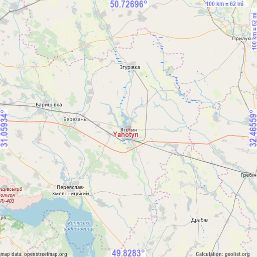
Yahotyn GPS coordinates[2]
50° 16' 47.1" North, 31° 45' 44.856" East
| Map corner | latitude | longitude |
|---|---|---|
| Upper-left | 50.72696°, | 31.05934° |
| Center: | 50.27975°, | 31.76246° |
| Lower-right: | 49.8283°, | 32.46559° |
| Map W x H: | 99.9×99.9 km | = 62.1×62.1mi |
| max Lat: | 52.18903° ⇑12.4% North |
| Yahotyn: | 50.27975° |
| min Lat: | ⇓87.6% South 44.39214° |
| min Long | Yahotyn | max Long |
| 22.20555° | 31.76246° | 40.13222° |
| W 41.8%⇐ | ⇒58.2% E |
Elevation
Elevation of Yahotyn is 130 m = 427 ft, and this is 25.8 m = 85 ft below average elevation for this country.
| Max E: |
886 m = 2907 ft | 51.1% |
| Avg. | 155.8 m = 511 ft | |
| Yahotyn | 130 m = 427 ft | |
Min E: |
-3 m = -10 ft | 48.9% |
See also: Ukraine elevation on elevation.city.
Geographical zone
Yahotyn is located in North temperate zone (between Tropic of Cancer and the Arctic Circle). Distance of this North polar circle is 1810.6 km =1125.1 mi to North.| Distance of | km | miles | from Yahotyn |
|---|---|---|---|
| North Pole | 4416.5 | 2744.3 | to North |
| Arctic Circle | 1810.6 | 1125.1 | to North |
| Tropic Cancer | 2984.7 | 1854.6 | to South |
| Equator | 5590.6 | 3473.8 | to South |


Nearby cities:
15 places around Yahotyn: (largest is in red/bold)
• Baryshivka
32.6 km =20.3 mi,  286°
286°
• Bogdanivka
19.2 km =11.9 mi,  110°
110°
• Boryspil’
57.9 km =36 mi,  278°
278°
• Chernyakhivka
13.8 km =8.6 mi,  119°
119°
• Chervone
15.7 km =9.8 mi,  56°
56°
• Drabiv
44.6 km =27.7 mi,  142°
142°
• Hrebinka
51.2 km =31.8 mi, 110°
• Kirove
46.6 km =29 mi, 282°
• Korniyivka
26.2 km =16.3 mi,  305°
305°
• Lozovyy Yar
17.3 km =10.7 mi,  74°
74°
• Pereiaslav-Khmelnytskyi
32.5 km =20.2 mi,  223°
223°
• Pryluky
56.3 km =35 mi,  51°
51°
• Pyryatyn
53 km =32.9 mi,  94°
94°
• Tsybli
34.7 km =21.6 mi,  204°
204°
• Zgurovka
24.8 km =15.4 mi,  3°
3°
Sources, notices
• [Note1] Compared only with cities in Ukraine existing in our database
• [Src1] Map data: © OpenStreetMap contributors (CC-BY-SA)
• [Src2] Other city data from geonames.org with taken over terms of usage.
• [Src3] Geographical zone / Annual Mean Temperature by Robert A. Rohde @ Wikipedia
