Korniyivka geodata
Korniyivka (Kyiv) is a populated place; located in Ukraine in Europe/Kiev (GMT+3) time zone. With population of 1,137 people, there are 1317 cities with bigger population in this country. Compared to other cities in Ukraine, 89.9% of cities are located further ↓South; 59.3% of cities are located further →East and 58.1% of cities have higher elevation than Korniyivka. Note1


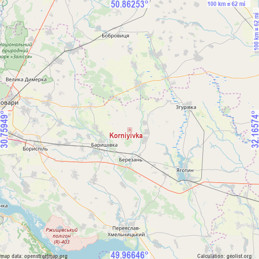
Korniyivka GPS coordinates[2]
50° 24' 59.796" North, 31° 27' 45.396" East
| Map corner | latitude | longitude |
|---|---|---|
| Upper-left | 50.86253°, | 30.75949° |
| Center: | 50.41661°, | 31.46261° |
| Lower-right: | 49.96646°, | 32.16574° |
| Map W x H: | 99.6×99.6 km | = 61.9×61.9mi |
| max Lat: | 52.18903° ⇑10.1% North |
| Korniyivka: | 50.41661° |
| min Lat: | ⇓89.9% South 44.39214° |
| min Long | Korniyivka | max Long |
| 22.20555° | 31.46261° | 40.13222° |
| W 40.7%⇐ | ⇒59.3% E |
Elevation
Elevation of Korniyivka is 112 m = 367 ft, and this is 43.8 m = 144 ft below average elevation for this country.
| Max E: |
886 m = 2907 ft | 58.1% |
| Avg. | 155.8 m = 511 ft | |
| Korniyivka | 112 m = 367 ft | |
Min E: |
-3 m = -10 ft | 41.9% |
See also: Ukraine elevation on elevation.city.
Geographical zone
Korniyivka is located in North temperate zone (between Tropic of Cancer and the Arctic Circle). Distance of this North polar circle is 1795.4 km =1115.6 mi to North.| Distance of | km | miles | from Korniyivka |
|---|---|---|---|
| North Pole | 4401.3 | 2734.8 | to North |
| Arctic Circle | 1795.4 | 1115.6 | to North |
| Tropic Cancer | 2999.9 | 1864.1 | to South |
| Equator | 5605.8 | 3483.3 | to South |


Nearby cities:
15 places around Korniyivka: (largest is in red/bold)
• Baryshivka
11.7 km =7.3 mi,  238°
238°
• Bobrovytsya
37 km =23 mi,  352°
352°
• Bogdanivka
45 km =28 mi,  119°
119°
• Boryspil’
36.7 km =22.8 mi,  258°
258°
• Chernyakhivka
39.9 km =24.8 mi, 123°
• Chervone
35 km =21.7 mi,  100°
100°
• Kirove
24.8 km =15.4 mi, 257°
• Kobyzhcha
45.9 km =28.5 mi,  3°
3°
• Lozovyy Yar
39.3 km =24.4 mi,  105°
105°
• Pereiaslav-Khmelnytskyi
38.8 km =24.1 mi,  181°
181°
• Trebukhiv
40.3 km =25 mi,  280°
280°
• Velyka Dymerka
44.2 km =27.5 mi,  296°
296°
• Voronkov
45.4 km =28.2 mi, 241°
• Yahotyn
26.2 km =16.3 mi,  125°
125°
• Zgurovka
24.7 km =15.3 mi,  67°
67°
Sources, notices
• [Note1] Compared only with cities in Ukraine existing in our database
• [Src1] Map data: © OpenStreetMap contributors (CC-BY-SA)
• [Src2] Other city data from geonames.org with taken over terms of usage.
• [Src3] Geographical zone / Annual Mean Temperature by Robert A. Rohde @ Wikipedia
