Chernyakhivka geodata
Chernyakhivka (Kyiv) is a populated place; located in Ukraine in Europe/Kiev (GMT+3) time zone. With population of 1,002 people, there are 1380 cities with bigger population in this country. Compared to other cities in Ukraine, 86.8% of cities are located further ↓South; 57.5% of cities are located further →East and 53.4% of cities have higher elevation than Chernyakhivka. Note1


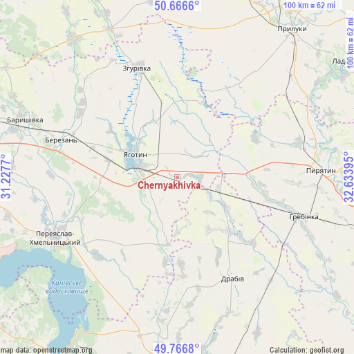
Chernyakhivka GPS coordinates[2]
50° 13' 7.752" North, 31° 55' 50.952" East
| Map corner | latitude | longitude |
|---|---|---|
| Upper-left | 50.6666°, | 31.2277° |
| Center: | 50.21882°, | 31.93082° |
| Lower-right: | 49.7668°, | 32.63395° |
| Map W x H: | 100×100 km | = 62.1×62.1mi |
| max Lat: | 52.18903° ⇑13.2% North |
| Chernyakhivka: | 50.21882° |
| min Lat: | ⇓86.8% South 44.39214° |
| min Long | Chernyakhivka | max Long |
| 22.20555° | 31.93082° | 40.13222° |
| W 42.5%⇐ | ⇒57.5% E |
Elevation
Elevation of Chernyakhivka is 124 m = 407 ft, and this is 31.8 m = 104 ft below average elevation for this country.
| Max E: |
886 m = 2907 ft | 53.4% |
| Avg. | 155.8 m = 511 ft | |
| Chernyakhivka | 124 m = 407 ft | |
Min E: |
-3 m = -10 ft | 46.6% |
See also: Ukraine elevation on elevation.city.
Geographical zone
Chernyakhivka is located in North temperate zone (between Tropic of Cancer and the Arctic Circle). Distance of this North polar circle is 1817.4 km =1129.3 mi to North.| Distance of | km | miles | from Chernyakhivka |
|---|---|---|---|
| North Pole | 4423.3 | 2748.5 | to North |
| Arctic Circle | 1817.4 | 1129.3 | to North |
| Tropic Cancer | 2977.9 | 1850.4 | to South |
| Equator | 5583.8 | 3469.6 | to South |


Nearby cities:
15 places around Chernyakhivka: (largest is in red/bold)
• Baryshivka
46.1 km =28.6 mi,  290°
290°
• Bogdanivka
6 km =3.7 mi,  90°
90°
• Chervone
15.4 km =9.6 mi,  4°
4°
• Drabiv
32.4 km =20.1 mi,  152°
152°
• Hrebinka
37.7 km =23.4 mi,  107°
107°
• Korniyivka
39.9 km =24.8 mi,  303°
303°
• Ladan
57 km =35.4 mi,  54°
54°
• Lozovyy Yar
12.4 km =7.7 mi,  22°
22°
• Pereiaslav-Khmelnytskyi
38.2 km =23.7 mi,  243°
243°
• Pryluky
52.7 km =32.7 mi,  37°
37°
• Pyryatyn
41 km =25.5 mi, 86°
• Tsybli
36.2 km =22.5 mi,  226°
226°
• Yahotyn
13.8 km =8.6 mi, 299°
• Zgurovka
33.2 km =20.6 mi,  341°
341°
• Zhuravka
55.4 km =34.4 mi,  58°
58°
Sources, notices
• [Note1] Compared only with cities in Ukraine existing in our database
• [Src1] Map data: © OpenStreetMap contributors (CC-BY-SA)
• [Src2] Other city data from geonames.org with taken over terms of usage.
• [Src3] Geographical zone / Annual Mean Temperature by Robert A. Rohde @ Wikipedia
