Lozovyy Yar geodata
Lozovyy Yar (Kyiv) is a populated place; located in Ukraine in Europe/Kiev (GMT+3) time zone. With population of 930 people, there are 1413 cities with bigger population in this country. Compared to other cities in Ukraine, 88.3% of cities are located further ↓South; 57.3% of cities are located further →East and 54.5% of cities have higher elevation than Lozovyy Yar. Note1


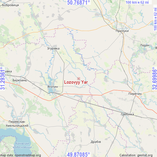
Lozovyy Yar GPS coordinates[2]
50° 19' 18.84" North, 31° 59' 48.228" East
| Map corner | latitude | longitude |
|---|---|---|
| Upper-left | 50.76871°, | 31.29361° |
| Center: | 50.3219°, | 31.99673° |
| Lower-right: | 49.87085°, | 32.69986° |
| Map W x H: | 99.8×99.8 km | = 62×62mi |
| max Lat: | 52.18903° ⇑11.7% North |
| Lozovyy Yar: | 50.3219° |
| min Lat: | ⇓88.3% South 44.39214° |
| min Long | Lozovyy Yar | max Long |
| 22.20555° | 31.99673° | 40.13222° |
| W 42.7%⇐ | ⇒57.3% E |
Elevation
Elevation of Lozovyy Yar is 121 m = 397 ft, and this is 34.8 m = 114 ft below average elevation for this country.
| Max E: |
886 m = 2907 ft | 54.5% |
| Avg. | 155.8 m = 511 ft | |
| Lozovyy Yar | 121 m = 397 ft | |
Min E: |
-3 m = -10 ft | 45.5% |
See also: Ukraine elevation on elevation.city.
Geographical zone
Lozovyy Yar is located in North temperate zone (between Tropic of Cancer and the Arctic Circle). Distance of this North polar circle is 1805.9 km =1122.1 mi to North.| Distance of | km | miles | from Lozovyy Yar |
|---|---|---|---|
| North Pole | 4411.8 | 2741.4 | to North |
| Arctic Circle | 1805.9 | 1122.1 | to North |
| Tropic Cancer | 2989.4 | 1857.5 | to South |
| Equator | 5595.3 | 3476.8 | to South |


Nearby cities:
15 places around Lozovyy Yar: (largest is in red/bold)
• Bogdanivka
11.6 km =7.2 mi,  173°
173°
• Chernyakhivka
12.4 km =7.7 mi,  202°
202°
• Chervone
5.2 km =3.2 mi,  318°
318°
• Drabiv
41.5 km =25.8 mi, 165°
• Hrebinka
38.7 km =24 mi,  126°
126°
• Korniyivka
39.3 km =24.4 mi,  285°
285°
• Ladan
46.9 km =29.1 mi,  62°
62°
• Lisovi Sorochyntsi
47.1 km =29.3 mi,  29°
29°
• Pereiaslav-Khmelnytskyi
48.1 km =29.9 mi,  233°
233°
• Pryluky
40.9 km =25.4 mi,  42°
42°
• Pyryatyn
37.3 km =23.2 mi,  103°
103°
• Tsybli
47.7 km =29.6 mi,  220°
220°
• Yahotyn
17.3 km =10.7 mi,  254°
254°
• Zgurovka
25.1 km =15.6 mi, 323°
• Zhuravka
45.9 km =28.5 mi,  67°
67°
Sources, notices
• [Note1] Compared only with cities in Ukraine existing in our database
• [Src1] Map data: © OpenStreetMap contributors (CC-BY-SA)
• [Src2] Other city data from geonames.org with taken over terms of usage.
• [Src3] Geographical zone / Annual Mean Temperature by Robert A. Rohde @ Wikipedia
