Zgurovka geodata
Zgurovka (Kyiv) is a seat of a second-order administrative division; located in Ukraine in Europe/Kiev (GMT+3) time zone. With population of 6,369 people, there are 549 cities with bigger population in this country. Compared to other cities in Ukraine, 91% of cities are located further ↓South; 58.1% of cities are located further →East and 52.7% of cities have higher elevation than Zgurovka. Note1


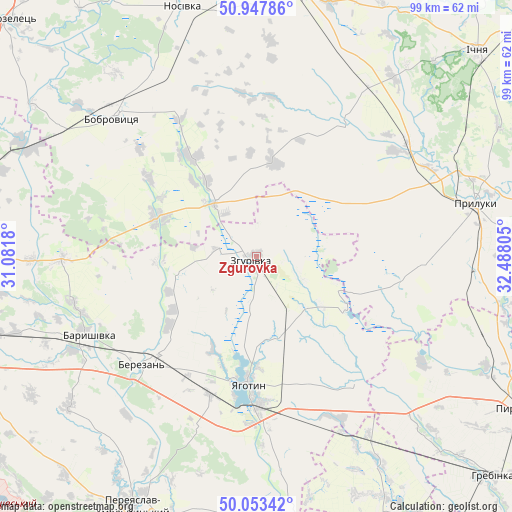
Zgurovka GPS coordinates[2]
50° 30' 9.936" North, 31° 47' 5.712" East
| Map corner | latitude | longitude |
|---|---|---|
| Upper-left | 50.94786°, | 31.0818° |
| Center: | 50.50276°, | 31.78492° |
| Lower-right: | 50.05342°, | 32.48805° |
| Map W x H: | 99.5×99.5 km | = 61.8×61.8mi |
| max Lat: | 52.18903° ⇑9% North |
| Zgurovka: | 50.50276° |
| min Lat: | ⇓91% South 44.39214° |
| min Long | Zgurovka | max Long |
| 22.20555° | 31.78492° | 40.13222° |
| W 41.9%⇐ | ⇒58.1% E |
Elevation
Elevation of Zgurovka is 126 m = 413 ft, and this is 29.8 m = 98 ft below average elevation for this country.
| Max E: |
886 m = 2907 ft | 52.7% |
| Avg. | 155.8 m = 511 ft | |
| Zgurovka | 126 m = 413 ft | |
Min E: |
-3 m = -10 ft | 47.3% |
See also: Ukraine elevation on elevation.city.
Geographical zone
Zgurovka is located in North temperate zone (between Tropic of Cancer and the Arctic Circle). Distance of this North polar circle is 1785.8 km =1109.6 mi to North.| Distance of | km | miles | from Zgurovka |
|---|---|---|---|
| North Pole | 4391.7 | 2728.9 | to North |
| Arctic Circle | 1785.8 | 1109.6 | to North |
| Tropic Cancer | 3009.5 | 1870 | to South |
| Equator | 5615.4 | 3489.2 | to South |


Nearby cities:
15 places around Zgurovka: (largest is in red/bold)
• Baryshivka
36.4 km =22.6 mi,  244°
244°
• Bobrovytsya
38.7 km =24 mi,  314°
314°
• Bogdanivka
35.6 km =22.1 mi,  152°
152°
• Chernyakhivka
33.2 km =20.6 mi,  161°
161°
• Chervone
19.9 km =12.4 mi,  144°
144°
• Druzhba
52.3 km =32.5 mi,  50°
50°
• Kirove
49.3 km =30.6 mi,  252°
252°
• Kobyzhcha
41.3 km =25.7 mi,  331°
331°
• Korniyivka
24.7 km =15.3 mi, 247°
• Lisovi Sorochyntsi
43.7 km =27.2 mi,  61°
61°
• Lozovyy Yar
25.1 km =15.6 mi, 143°
• Nosivka
49.8 km =30.9 mi,  343°
343°
• Pryluky
43.8 km =27.2 mi,  76°
76°
• Talalayivka
51.5 km =32 mi,  10°
10°
• Yahotyn
24.8 km =15.4 mi,  183°
183°
Sources, notices
• [Note1] Compared only with cities in Ukraine existing in our database
• [Src1] Map data: © OpenStreetMap contributors (CC-BY-SA)
• [Src2] Other city data from geonames.org with taken over terms of usage.
• [Src3] Geographical zone / Annual Mean Temperature by Robert A. Rohde @ Wikipedia
