Pryluky geodata
Pryluky (Chernihiv) is a seat of a second-order administrative division; located in Ukraine in Europe/Kiev (GMT+3) time zone. With population of 62,823 people, there are 75 cities with bigger population in this country. Compared to other cities in Ukraine, 92% of cities are located further ↓South; 55.9% of cities are located further →East and 52.2% of cities have higher elevation than Pryluky. Note1


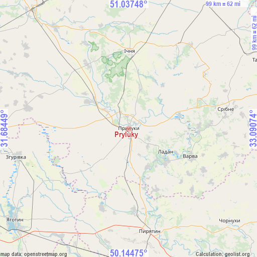
Pryluky GPS coordinates[2]
50° 35' 35.628" North, 32° 23' 15.396" East
| Map corner | latitude | longitude |
|---|---|---|
| Upper-left | 51.03748°, | 31.68449° |
| Center: | 50.59323°, | 32.38761° |
| Lower-right: | 50.14475°, | 33.09074° |
| Map W x H: | 99.3×99.3 km | = 61.7×61.7mi |
| max Lat: | 52.18903° ⇑8% North |
| Pryluky: | 50.59323° |
| min Lat: | ⇓92% South 44.39214° |
| min Long | Pryluky | max Long |
| 22.20555° | 32.38761° | 40.13222° |
| W 44.1%⇐ | ⇒55.9% E |
Elevation
Elevation of Pryluky is 127 m = 417 ft, and this is 28.8 m = 94 ft below average elevation for this country.
| Max E: |
886 m = 2907 ft | 52.2% |
| Avg. | 155.8 m = 511 ft | |
| Pryluky | 127 m = 417 ft | |
Min E: |
-3 m = -10 ft | 47.8% |
See also: Pryluky elevation on elevation.city.
Geographical zone
Pryluky is located in North temperate zone (between Tropic of Cancer and the Arctic Circle). Distance of this North polar circle is 1775.7 km =1103.4 mi to North.| Distance of | km | miles | from Pryluky |
|---|---|---|---|
| North Pole | 4381.6 | 2722.6 | to North |
| Arctic Circle | 1775.7 | 1103.4 | to North |
| Tropic Cancer | 3019.5 | 1876.2 | to South |
| Equator | 5625.4 | 3495.5 | to South |


Nearby cities:
15 places around Pryluky: (largest is in red/bold)
• Bogdanivka
49.4 km =30.7 mi,  212°
212°
• Chernyakhivka
52.7 km =32.7 mi,  217°
217°
• Chervone
40.7 km =25.3 mi,  229°
229°
• Dihtyari
27 km =16.8 mi,  92°
92°
• Druzhba
23.3 km =14.5 mi,  354°
354°
• Ichnya
30 km =18.6 mi,  0°
0°
• Ladan
16 km =9.9 mi,  120°
120°
• Lisovi Sorochyntsi
11.4 km =7.1 mi,  338°
338°
• Lozovyy Yar
40.9 km =25.4 mi, 222°
• Pyryatyn
39.9 km =24.8 mi,  167°
167°
• Sribne
38.3 km =23.8 mi,  78°
78°
• Talalayivka
52.2 km =32.4 mi,  321°
321°
• Varva
25.9 km =16.1 mi,  114°
114°
• Zgurovka
43.8 km =27.2 mi,  256°
256°
• Zhuravka
19.2 km =11.9 mi,  130°
130°
Sources, notices
• [Note1] Compared only with cities in Ukraine existing in our database
• [Src1] Map data: © OpenStreetMap contributors (CC-BY-SA)
• [Src2] Other city data from geonames.org with taken over terms of usage.
• [Src3] Geographical zone / Annual Mean Temperature by Robert A. Rohde @ Wikipedia
