Karlivka geodata
Karlivka (Poltava) is a seat of a second-order administrative division; located in Ukraine in Europe/Kiev (GMT+3) time zone. With population of 17,226 people, there are 226 cities with bigger population in this country. Compared to other cities in Ukraine, 74.1% of cities are located further ↓South; 81.6% of cities are located further ←West and 54.6% of cities have lower elevation than Karlivka. Note1


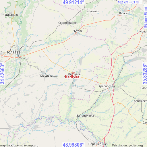
Karlivka GPS coordinates[2]
49° 27' 26.028" North, 35° 7' 47.1" East
| Map corner | latitude | longitude |
|---|---|---|
| Upper-left | 49.91214°, | 34.42663° |
| Center: | 49.45723°, | 35.12975° |
| Lower-right: | 48.99806°, | 35.83288° |
| Map W x H: | 101.6×101.6 km | = 63.1×63.1mi |
| max Lat: | 52.18903° ⇑25.9% North |
| Karlivka: | 49.45723° |
| min Lat: | ⇓74.1% South 44.39214° |
| min Long | Karlivka | max Long |
| 22.20555° | 35.12975° | 40.13222° |
| W 81.6%⇐ | ⇒18.4% E |
Elevation
Elevation of Karlivka is 151 m = 495 ft, and this is 4.8 m = 16 ft below average elevation for this country.
| Max E: |
886 m = 2907 ft | 45.4% |
| Avg. | 155.8 m = 511 ft | |
| Karlivka | 151 m = 495 ft | |
Min E: |
-3 m = -10 ft | 54.6% |
See also: Ukraine elevation on elevation.city.
Geographical zone
Karlivka is located in North temperate zone (between Tropic of Cancer and the Arctic Circle). Distance of this North polar circle is 1902 km =1181.8 mi to North.| Distance of | km | miles | from Karlivka |
|---|---|---|---|
| North Pole | 4507.9 | 2801.1 | to North |
| Arctic Circle | 1902 | 1181.8 | to North |
| Tropic Cancer | 2893.2 | 1797.8 | to South |
| Equator | 5499.1 | 3417 | to South |


Nearby cities:
15 places around Karlivka: (largest is in red/bold)
• Berezivka
41.8 km =26 mi,  92°
92°
• Chapayeve
54.8 km =34.1 mi,  100°
100°
• Chutove
28.3 km =17.6 mi,  5°
5°
• Dykan’ka
59.6 km =37 mi,  313°
313°
• Hupalivka
47.9 km =29.8 mi,  216°
216°
• Kehychivka
49.5 km =30.8 mi,  112°
112°
• Kolomak
44.4 km =27.6 mi,  16°
16°
• Krasnohrad
24.1 km =15 mi, 110°
• Mashivka
19.1 km =11.9 mi,  265°
265°
• Nova Vodolaha
60.5 km =37.6 mi,  61°
61°
• Poltava
45.1 km =28 mi,  289°
289°
• Valky
54.6 km =33.9 mi,  39°
39°
• Varvarivka
10.3 km =6.4 mi,  29°
29°
• Verbivka
29.5 km =18.3 mi, 98°
• Zachepylivka
30.3 km =18.8 mi,  164°
164°
Sources, notices
• [Note1] Compared only with cities in Ukraine existing in our database
• [Src1] Map data: © OpenStreetMap contributors (CC-BY-SA)
• [Src2] Other city data from geonames.org with taken over terms of usage.
• [Src3] Geographical zone / Annual Mean Temperature by Robert A. Rohde @ Wikipedia
