Krasnyy Kut geodata
Krasnyy Kut (Luhansk) is a populated place; located in Ukraine in Europe/Zaporozhye (GMT+3) time zone. With population of 2,983 people, there are 946 cities with bigger population in this country. Compared to other cities in Ukraine, 52.3% of cities are located further ↑North; 97.8% of cities are located further ←West and 56% of cities have lower elevation than Krasnyy Kut. Note1


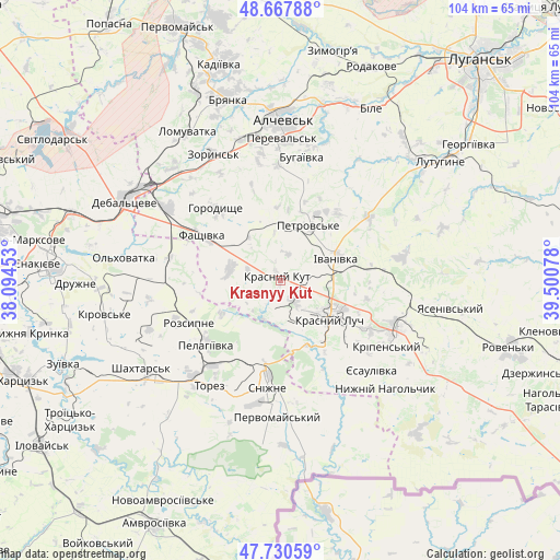
Krasnyy Kut GPS coordinates[2]
48° 12' 4.968" North, 38° 47' 51.54" East
| Map corner | latitude | longitude |
|---|---|---|
| Upper-left | 48.66788°, | 38.09453° |
| Center: | 48.20138°, | 38.79765° |
| Lower-right: | 47.73059°, | 39.50078° |
| Map W x H: | 104.2×104.2 km | = 64.7×64.7mi |
| max Lat: | 52.18903° ⇑52.3% North |
| Krasnyy Kut: | 48.20138° |
| min Lat: | ⇓47.7% South 44.39214° |
| min Long | Krasnyy Kut | max Long |
| 22.20555° | 38.79765° | 40.13222° |
| W 97.8%⇐ | ⇒2.2% E |
Elevation
Elevation of Krasnyy Kut is 155 m = 509 ft, and this is 0.80000000000001 m = 3 ft below average elevation for this country.
| Max E: |
886 m = 2907 ft | 44% |
| Avg. | 155.8 m = 511 ft | |
| Krasnyy Kut | 155 m = 509 ft | |
Min E: |
-3 m = -10 ft | 56% |
See also: Ukraine elevation on elevation.city.
Geographical zone
Krasnyy Kut is located in North temperate zone (between Tropic of Cancer and the Arctic Circle). Distance of this North polar circle is 2041.7 km =1268.7 mi to North.| Distance of | km | miles | from Krasnyy Kut |
|---|---|---|---|
| North Pole | 4647.6 | 2887.9 | to North |
| Arctic Circle | 2041.7 | 1268.7 | to North |
| Tropic Cancer | 2753.6 | 1711 | to South |
| Equator | 5359.5 | 3330.2 | to South |


Nearby cities:
15 places around Krasnyy Kut: (largest is in red/bold)
• Antratsyt
23.8 km =14.8 mi,  113°
113°
• Artemivs’k
27 km =16.8 mi,  349°
349°
• Bayrachky
25.7 km =16 mi,  325°
325°
• Chornukhyne
24.5 km =15.2 mi,  303°
303°
• Chystyakove
23.4 km =14.5 mi,  219°
219°
• Krasnyy Luch
12.4 km =7.7 mi,  123°
123°
• Kripens’kyy
23.8 km =14.8 mi,  125°
125°
• Millerovo
27.5 km =17.1 mi,  97°
97°
• Miusyns’k
15.9 km =9.9 mi,  150°
150°
• Pereval’s’k
26.5 km =16.5 mi,  7°
7°
• Rozsypne
17.4 km =10.8 mi,  250°
250°
• Snizhne
19.6 km =12.2 mi,  185°
185°
• Stizhkivs’ke
24.7 km =15.3 mi, 246°
• Zalesnoye
19 km =11.8 mi,  177°
177°
• Zoryns’k
26.7 km =16.6 mi, 331°
Sources, notices
• [Note1] Compared only with cities in Ukraine existing in our database
• [Src1] Map data: © OpenStreetMap contributors (CC-BY-SA)
• [Src2] Other city data from geonames.org with taken over terms of usage.
• [Src3] Geographical zone / Annual Mean Temperature by Robert A. Rohde @ Wikipedia
