Ternuvate geodata
Ternuvate (Zaporizhia) is a populated place; located in Ukraine in Europe/Zaporozhye (GMT+3) time zone. With population of 1,510 people, there are 1207 cities with bigger population in this country. Compared to other cities in Ukraine, 58.3% of cities are located further ↑North; 87.6% of cities are located further ←West and 55.5% of cities have lower elevation than Ternuvate. Note1


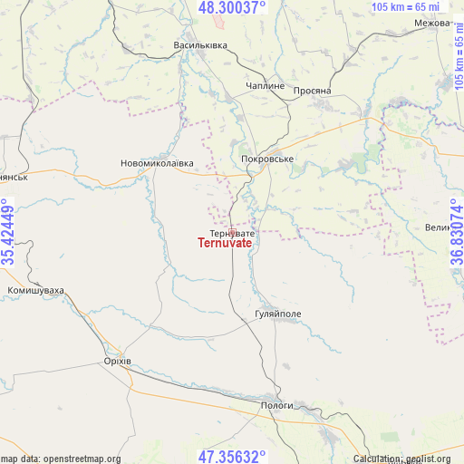
Ternuvate GPS coordinates[2]
47° 49' 49.764" North, 36° 7' 39.396" East
| Map corner | latitude | longitude |
|---|---|---|
| Upper-left | 48.30037°, | 35.42449° |
| Center: | 47.83049°, | 36.12761° |
| Lower-right: | 47.35632°, | 36.83074° |
| Map W x H: | 105×105 km | = 65.2×65.2mi |
| max Lat: | 52.18903° ⇑58.3% North |
| Ternuvate: | 47.83049° |
| min Lat: | ⇓41.7% South 44.39214° |
| min Long | Ternuvate | max Long |
| 22.20555° | 36.12761° | 40.13222° |
| W 87.6%⇐ | ⇒12.4% E |
Elevation
Elevation of Ternuvate is 154 m = 505 ft, and this is 1.8 m = 6 ft below average elevation for this country.
| Max E: |
886 m = 2907 ft | 44.5% |
| Avg. | 155.8 m = 511 ft | |
| Ternuvate | 154 m = 505 ft | |
Min E: |
-3 m = -10 ft | 55.5% |
See also: Ukraine elevation on elevation.city.
Geographical zone
Ternuvate is located in North temperate zone (between Tropic of Cancer and the Arctic Circle). Distance of this North polar circle is 2082.9 km =1294.3 mi to North.| Distance of | km | miles | from Ternuvate |
|---|---|---|---|
| North Pole | 4688.8 | 2913.5 | to North |
| Arctic Circle | 2082.9 | 1294.3 | to North |
| Tropic Cancer | 2712.3 | 1685.3 | to South |
| Equator | 5318.3 | 3304.6 | to South |


Nearby cities:
15 places around Ternuvate: (largest is in red/bold)
• Chapayevka
43.1 km =26.8 mi,  157°
157°
• Hulyaypole
20.9 km =13 mi,  152°
152°
• Kirove
37.9 km =23.5 mi,  238°
238°
• Komyshuvakha
46.5 km =28.9 mi,  254°
254°
• Mala Tokmachka
37.2 km =23.1 mi,  208°
208°
• Mezhova
65.2 km =40.5 mi,  43°
43°
• Novomykolayivka
23.1 km =14.4 mi,  315°
315°
• Orikhiv
38.9 km =24.2 mi,  221°
221°
• Pokrovs’ke
18 km =11.2 mi,  23°
23°
• Polohy
39.6 km =24.6 mi,  166°
166°
• Preobrazhenka
37 km =23 mi, 218°
• Vasyl’kivka
42.6 km =26.5 mi,  349°
349°
• Velyka Novosilka
52.8 km =32.8 mi,  88°
88°
• Vil’nyans’k
53.1 km =33 mi,  283°
283°
• Zaliznychne
20 km =12.4 mi, 171°
Sources, notices
• [Note1] Compared only with cities in Ukraine existing in our database
• [Src1] Map data: © OpenStreetMap contributors (CC-BY-SA)
• [Src2] Other city data from geonames.org with taken over terms of usage.
• [Src3] Geographical zone / Annual Mean Temperature by Robert A. Rohde @ Wikipedia
