Pokrovs’ke geodata
Pokrovs’ke (Dnipropetrovsk) is a seat of a second-order administrative division; located in Ukraine in Europe/Kiev (GMT+3) time zone. In our database, there are 1661 cities with bigger population. Compared to other cities in Ukraine, 56.9% of cities are located further ↑North; 88.3% of cities are located further ←West and 63% of cities have higher elevation than Pokrovs’ke. Note1


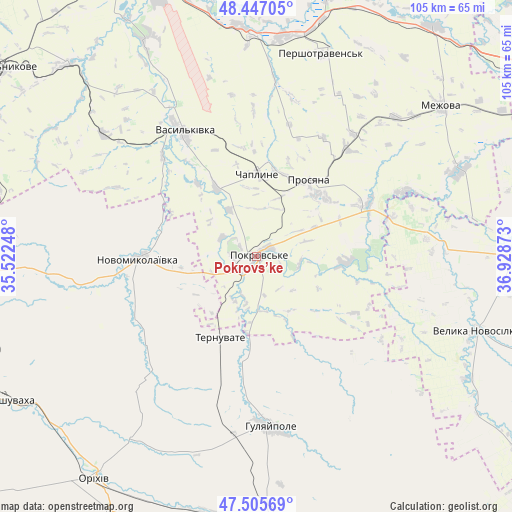
Pokrovs’ke GPS coordinates[2]
47° 58' 42.672" North, 36° 13' 32.16" East
| Map corner | latitude | longitude |
|---|---|---|
| Upper-left | 48.44705°, | 35.52248° |
| Center: | 47.97852°, | 36.2256° |
| Lower-right: | 47.50569°, | 36.92873° |
| Map W x H: | 104.7×104.7 km | = 65.1×65.1mi |
| max Lat: | 52.18903° ⇑56.9% North |
| Pokrovs’ke: | 47.97852° |
| min Lat: | ⇓43.1% South 44.39214° |
| min Long | Pokrovs’ke | max Long |
| 22.20555° | 36.2256° | 40.13222° |
| W 88.3%⇐ | ⇒11.7% E |
Elevation
Elevation of Pokrovs’ke is 97 m = 318 ft, and this is 58.8 m = 193 ft below average elevation for this country.
| Max E: |
886 m = 2907 ft | 63% |
| Avg. | 155.8 m = 511 ft | |
| Pokrovs’ke | 97 m = 318 ft | |
Min E: |
-3 m = -10 ft | 37% |
See also: Ukraine elevation on elevation.city.
Geographical zone
Pokrovs’ke is located in North temperate zone (between Tropic of Cancer and the Arctic Circle). Distance of this North polar circle is 2066.5 km =1284.1 mi to North.| Distance of | km | miles | from Pokrovs’ke |
|---|---|---|---|
| North Pole | 4672.4 | 2903.3 | to North |
| Arctic Circle | 2066.5 | 1284.1 | to North |
| Tropic Cancer | 2728.8 | 1695.6 | to South |
| Equator | 5334.7 | 3314.8 | to South |


Nearby cities:
15 places around Pokrovs’ke: (largest is in red/bold)
• Chapayevka
57.1 km =35.5 mi,  170°
170°
• Hulyaypole
35.1 km =21.8 mi,  176°
176°
• Kirove
53.6 km =33.3 mi,  227°
227°
• Mala Tokmachka
55.2 km =34.3 mi,  206°
206°
• Mezhova
48.6 km =30.2 mi,  51°
51°
• Novomykolayivka
23.5 km =14.6 mi,  269°
269°
• Orikhiv
56.3 km =35 mi,  215°
215°
• Petropavlivka
55.4 km =34.4 mi,  16°
16°
• Polohy
55 km =34.2 mi, 177°
• Preobrazhenka
54.6 km =33.9 mi, 214°
• Ternuvate
18 km =11.2 mi,  203°
203°
• Vasyl’kivka
29.5 km =18.3 mi,  329°
329°
• Velyka Novosilka
47.8 km =29.7 mi,  108°
108°
• Vil’nyans’k
59 km =36.7 mi, 266°
• Zaliznychne
36.5 km =22.7 mi,  187°
187°
Sources, notices
• [Note1] Compared only with cities in Ukraine existing in our database
• [Src1] Map data: © OpenStreetMap contributors (CC-BY-SA)
• [Src2] Other city data from geonames.org with taken over terms of usage.
• [Src3] Geographical zone / Annual Mean Temperature by Robert A. Rohde @ Wikipedia
