Sumy geodata
Sumy is a seat of a first-order administrative division; located in Ukraine in Europe/Kiev (GMT+3) time zone. With population of 294,456 people, there are 20 cities with bigger population in this country. Compared to other cities in Ukraine, 95.2% of cities are located further ↓South; 77.7% of cities are located further ←West and 52.3% of cities have lower elevation than Sumy. Note1


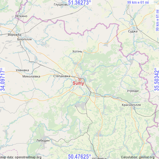
Sumy GPS coordinates[2]
50° 55' 17.76" North, 34° 48' 1.044" East
| Map corner | latitude | longitude |
|---|---|---|
| Upper-left | 51.36273°, | 34.09717° |
| Center: | 50.9216°, | 34.80029° |
| Lower-right: | 50.47625°, | 35.50342° |
| Map W x H: | 98.6×98.6 km | = 61.3×61.3mi |
| max Lat: | 52.18903° ⇑4.8% North |
| Sumy: | 50.9216° |
| min Lat: | ⇓95.2% South 44.39214° |
| min Long | Sumy | max Long |
| 22.20555° | 34.80029° | 40.13222° |
| W 77.7%⇐ | ⇒22.3% E |
Elevation
Elevation of Sumy is 143 m = 469 ft, and this is 12.8 m = 42 ft below average elevation for this country.
| Max E: |
886 m = 2907 ft | 47.7% |
| Avg. | 155.8 m = 511 ft | |
| Sumy | 143 m = 469 ft | |
Min E: |
-3 m = -10 ft | 52.3% |
See also: Sumy elevation on elevation.city.
Geographical zone
Sumy is located in North temperate zone (between Tropic of Cancer and the Arctic Circle). Distance of this North polar circle is 1739.2 km =1080.7 mi to North.| Distance of | km | miles | from Sumy |
|---|---|---|---|
| North Pole | 4345.1 | 2699.9 | to North |
| Arctic Circle | 1739.2 | 1080.7 | to North |
| Tropic Cancer | 3056 | 1898.9 | to South |
| Equator | 5662 | 3518.2 | to South |


Nearby cities:
15 places around Sumy: (largest is in red/bold)
• Bilopillya
42.5 km =26.4 mi,  306°
306°
• Boromlya
35.8 km =22.2 mi,  160°
160°
• Buryn’
74.2 km =46.1 mi,  294°
294°
• Krasnopillya
36.2 km =22.5 mi,  116°
116°
• Kyrykivka
65.8 km =40.9 mi, 160°
• Lebedyn
43.5 km =27 mi,  210°
210°
• Mezenivka
48.1 km =29.9 mi,  131°
131°
• Nedryhayliv
65.6 km =40.8 mi,  261°
261°
• Nyzy
15.5 km =9.6 mi,  184°
184°
• Okhtyrka
68.3 km =42.4 mi,  174°
174°
• Terny
58.6 km =36.4 mi,  277°
277°
• Trostyanets’
49.9 km =31 mi, 166°
• Velyka Pysarivka
73.1 km =45.4 mi,  139°
139°
• Verkhnya Syrovatka
15.1 km =9.4 mi, 132°
• Vorozhba
49.3 km =30.6 mi,  304°
304°
Sources, notices
• [Note1] Compared only with cities in Ukraine existing in our database
• [Src1] Map data: © OpenStreetMap contributors (CC-BY-SA)
• [Src2] Other city data from geonames.org with taken over terms of usage.
• [Src3] Geographical zone / Annual Mean Temperature by Robert A. Rohde @ Wikipedia
