Terny geodata
Terny (Sumy) is a populated place; located in Ukraine in Europe/Kiev (GMT+3) time zone. With population of 3,661 people, there are 802 cities with bigger population in this country. Compared to other cities in Ukraine, 95.6% of cities are located further ↓South; 61.7% of cities are located further ←West and 50.5% of cities have lower elevation than Terny. Note1


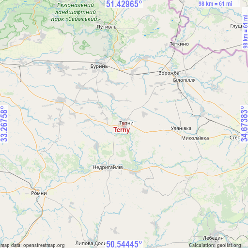
Terny GPS coordinates[2]
50° 59' 20.976" North, 33° 58' 14.52" East
| Map corner | latitude | longitude |
|---|---|---|
| Upper-left | 51.42965°, | 33.26758° |
| Center: | 50.98916°, | 33.9707° |
| Lower-right: | 50.54445°, | 34.67383° |
| Map W x H: | 98.4×98.4 km | = 61.1×61.1mi |
| max Lat: | 52.18903° ⇑4.4% North |
| Terny: | 50.98916° |
| min Lat: | ⇓95.6% South 44.39214° |
| min Long | Terny | max Long |
| 22.20555° | 33.9707° | 40.13222° |
| W 61.7%⇐ | ⇒38.3% E |
Elevation
Elevation of Terny is 138 m = 453 ft, and this is 17.8 m = 58 ft below average elevation for this country.
| Max E: |
886 m = 2907 ft | 49.5% |
| Avg. | 155.8 m = 511 ft | |
| Terny | 138 m = 453 ft | |
Min E: |
-3 m = -10 ft | 50.5% |
See also: Ukraine elevation on elevation.city.
Geographical zone
Terny is located in North temperate zone (between Tropic of Cancer and the Arctic Circle). Distance of this North polar circle is 1731.7 km =1076 mi to North.| Distance of | km | miles | from Terny |
|---|---|---|---|
| North Pole | 4337.6 | 2695.3 | to North |
| Arctic Circle | 1731.7 | 1076 | to North |
| Tropic Cancer | 3063.5 | 1903.6 | to South |
| Equator | 5669.5 | 3522.9 | to South |


Nearby cities:
15 places around Terny: (largest is in red/bold)
• Bilopillya
29.9 km =18.6 mi,  53°
53°
• Buryn’
25.2 km =15.7 mi,  337°
337°
• Hadyach
68.7 km =42.7 mi,  178°
178°
• Konotop
60.4 km =37.5 mi,  297°
297°
• Lebedyn
57.7 km =35.9 mi,  141°
141°
• Lypova Dolyna
48.8 km =30.3 mi,  194°
194°
• Nedryhayliv
18.5 km =11.5 mi,  200°
200°
• Nyzy
61.5 km =38.2 mi,  111°
111°
• Putyvl’
39.3 km =24.4 mi,  349°
349°
• Romny
43.7 km =27.2 mi,  232°
232°
• Shalyhyne
65.6 km =40.8 mi,  9°
9°
• Sloboda
34.4 km =21.4 mi,  312°
312°
• Sumy
58.6 km =36.4 mi,  97°
97°
• Talalayivka
60.3 km =37.5 mi,  253°
253°
• Vorozhba
26.8 km =16.7 mi,  40°
40°
Sources, notices
• [Note1] Compared only with cities in Ukraine existing in our database
• [Src1] Map data: © OpenStreetMap contributors (CC-BY-SA)
• [Src2] Other city data from geonames.org with taken over terms of usage.
• [Src3] Geographical zone / Annual Mean Temperature by Robert A. Rohde @ Wikipedia
