Lebedyn geodata
Lebedyn (Sumy) is a seat of a second-order administrative division; located in Ukraine in Europe/Kiev (GMT+3) time zone. With population of 27,695 people, there are 154 cities with bigger population in this country. Compared to other cities in Ukraine, 91.9% of cities are located further ↓South; 73.3% of cities are located further ←West and 54% of cities have higher elevation than Lebedyn. Note1


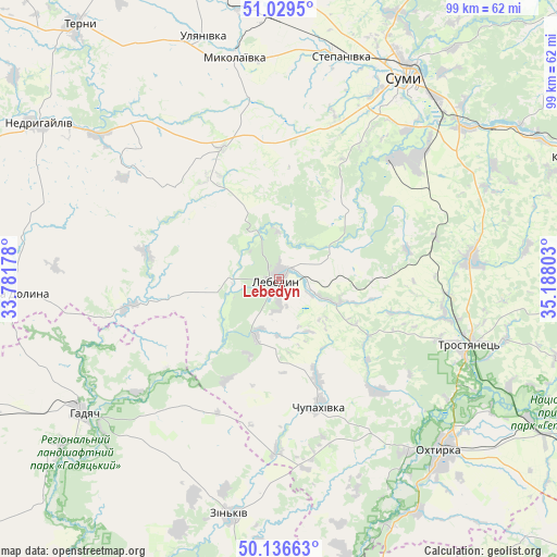
Lebedyn GPS coordinates[2]
50° 35' 6.648" North, 34° 29' 5.64" East
| Map corner | latitude | longitude |
|---|---|---|
| Upper-left | 51.0295°, | 33.78178° |
| Center: | 50.58518°, | 34.4849° |
| Lower-right: | 50.13663°, | 35.18803° |
| Map W x H: | 99.3×99.3 km | = 61.7×61.7mi |
| max Lat: | 52.18903° ⇑8.1% North |
| Lebedyn: | 50.58518° |
| min Lat: | ⇓91.9% South 44.39214° |
| min Long | Lebedyn | max Long |
| 22.20555° | 34.4849° | 40.13222° |
| W 73.3%⇐ | ⇒26.7% E |
Elevation
Elevation of Lebedyn is 122 m = 400 ft, and this is 33.8 m = 111 ft below average elevation for this country.
| Max E: |
886 m = 2907 ft | 54% |
| Avg. | 155.8 m = 511 ft | |
| Lebedyn | 122 m = 400 ft | |
Min E: |
-3 m = -10 ft | 46% |
See also: Ukraine elevation on elevation.city.
Geographical zone
Lebedyn is located in North temperate zone (between Tropic of Cancer and the Arctic Circle). Distance of this North polar circle is 1776.6 km =1103.9 mi to North.| Distance of | km | miles | from Lebedyn |
|---|---|---|---|
| North Pole | 4382.5 | 2723.2 | to North |
| Arctic Circle | 1776.6 | 1103.9 | to North |
| Tropic Cancer | 3018.6 | 1875.7 | to South |
| Equator | 5624.5 | 3494.9 | to South |


Nearby cities:
15 places around Lebedyn: (largest is in red/bold)
• Boromlya
34.5 km =21.4 mi,  83°
83°
• Hadyach
42.3 km =26.3 mi,  235°
235°
• Kotel’va
60.6 km =37.7 mi,  161°
161°
• Krasnopillya
58.5 km =36.4 mi,  68°
68°
• Kyrykivka
50.9 km =31.6 mi,  118°
118°
• Lypova Dolyna
48.6 km =30.2 mi,  267°
267°
• Mezenivka
58.7 km =36.5 mi, 84°
• Nedryhayliv
51 km =31.7 mi,  302°
302°
• Nyzy
30.5 km =19 mi,  43°
43°
• Okhtyrka
42.3 km =26.3 mi,  136°
136°
• Sumy
43.5 km =27 mi,  30°
30°
• Terny
57.7 km =35.9 mi,  321°
321°
• Trostyanets’
35.8 km =22.2 mi,  108°
108°
• Verkhnya Syrovatka
43 km =26.7 mi,  50°
50°
• Zin’kiv
42.8 km =26.6 mi,  191°
191°
Sources, notices
• [Note1] Compared only with cities in Ukraine existing in our database
• [Src1] Map data: © OpenStreetMap contributors (CC-BY-SA)
• [Src2] Other city data from geonames.org with taken over terms of usage.
• [Src3] Geographical zone / Annual Mean Temperature by Robert A. Rohde @ Wikipedia
