Krasnopillya geodata
Krasnopillya (Sumy) is a seat of a second-order administrative division; located in Ukraine in Europe/Kiev (GMT+3) time zone. With population of 8,603 people, there are 410 cities with bigger population in this country. Compared to other cities in Ukraine, 94% of cities are located further ↓South; 83.2% of cities are located further ←West and 61.9% of cities have lower elevation than Krasnopillya. Note1


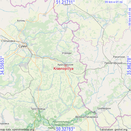
Krasnopillya GPS coordinates[2]
50° 46' 28.488" North, 35° 15' 34.74" East
| Map corner | latitude | longitude |
|---|---|---|
| Upper-left | 51.21711°, | 34.55653° |
| Center: | 50.77458°, | 35.25965° |
| Lower-right: | 50.32783°, | 35.96278° |
| Map W x H: | 98.9×98.9 km | = 61.5×61.5mi |
| max Lat: | 52.18903° ⇑6% North |
| Krasnopillya: | 50.77458° |
| min Lat: | ⇓94% South 44.39214° |
| min Long | Krasnopillya | max Long |
| 22.20555° | 35.25965° | 40.13222° |
| W 83.2%⇐ | ⇒16.8% E |
Elevation
Elevation of Krasnopillya is 175 m = 574 ft, and this is 19.2 m = 63 ft above average elevation for this country.
| Max E: |
886 m = 2907 ft | 38.1% |
| Krasnopillya | 175 m 574 ft | |
| Avg. | 155.8 m = 511 ft | |
Min E: |
-3 m = -10 ft | 61.9% |
See also: Ukraine elevation on elevation.city.
Geographical zone
Krasnopillya is located in North temperate zone (between Tropic of Cancer and the Arctic Circle). Distance of this North polar circle is 1755.6 km =1090.9 mi to North.| Distance of | km | miles | from Krasnopillya |
|---|---|---|---|
| North Pole | 4361.5 | 2710.1 | to North |
| Arctic Circle | 1755.6 | 1090.9 | to North |
| Tropic Cancer | 3039.7 | 1888.8 | to South |
| Equator | 5645.6 | 3508 | to South |


Nearby cities:
15 places around Krasnopillya: (largest is in red/bold)
• Bilopillya
78.4 km =48.7 mi,  302°
302°
• Bohodukhiv
70.4 km =43.7 mi,  164°
164°
• Boromlya
26.8 km =16.7 mi,  229°
229°
• Huty
71.6 km =44.5 mi,  175°
175°
• Krasnokuts’k
79.1 km =49.2 mi, 184°
• Kyrykivka
46.8 km =29.1 mi,  192°
192°
• Lebedyn
58.5 km =36.4 mi,  248°
248°
• Mezenivka
16 km =9.9 mi,  166°
166°
• Nyzy
33.4 km =20.8 mi,  271°
271°
• Okhtyrka
57.6 km =35.8 mi,  206°
206°
• Sumy
36.2 km =22.5 mi, 296°
• Trostyanets’
38.3 km =23.8 mi, 212°
• Velyka Pysarivka
41.9 km =26 mi, 158°
• Verkhnya Syrovatka
22 km =13.7 mi,  285°
285°
• Zolochiv
75 km =46.6 mi,  137°
137°
Sources, notices
• [Note1] Compared only with cities in Ukraine existing in our database
• [Src1] Map data: © OpenStreetMap contributors (CC-BY-SA)
• [Src2] Other city data from geonames.org with taken over terms of usage.
• [Src3] Geographical zone / Annual Mean Temperature by Robert A. Rohde @ Wikipedia
