Bakhmach geodata
Bakhmach (Chernihiv) is a populated place; located in Ukraine in Europe/Kiev (GMT+3) time zone. With population of 23,379 people, there are 177 cities with bigger population in this country. Compared to other cities in Ukraine, 96.5% of cities are located further ↓South; 53.4% of cities are located further →East and 52.6% of cities have lower elevation than Bakhmach. Note1


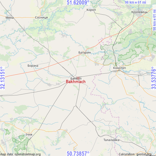
Bakhmach GPS coordinates[2]
51° 10' 53.184" North, 32° 50' 4.668" East
| Map corner | latitude | longitude |
|---|---|---|
| Upper-left | 51.62009°, | 32.13151° |
| Center: | 51.18144°, | 32.83463° |
| Lower-right: | 50.73857°, | 33.53776° |
| Map W x H: | 98×98 km | = 60.9×60.9mi |
| max Lat: | 52.18903° ⇑3.5% North |
| Bakhmach: | 51.18144° |
| min Lat: | ⇓96.5% South 44.39214° |
| min Long | Bakhmach | max Long |
| 22.20555° | 32.83463° | 40.13222° |
| W 46.6%⇐ | ⇒53.4% E |
Elevation
Elevation of Bakhmach is 144 m = 472 ft, and this is 11.8 m = 39 ft below average elevation for this country.
| Max E: |
886 m = 2907 ft | 47.4% |
| Avg. | 155.8 m = 511 ft | |
| Bakhmach | 144 m = 472 ft | |
Min E: |
-3 m = -10 ft | 52.6% |
See also: Ukraine elevation on elevation.city.
Geographical zone
Bakhmach is located in North temperate zone (between Tropic of Cancer and the Arctic Circle). Distance of this North polar circle is 1710.3 km =1062.7 mi to North.| Distance of | km | miles | from Bakhmach |
|---|---|---|---|
| North Pole | 4316.2 | 2682 | to North |
| Arctic Circle | 1710.3 | 1062.7 | to North |
| Tropic Cancer | 3084.9 | 1916.9 | to South |
| Equator | 5690.8 | 3536.1 | to South |


Nearby cities:
15 places around Bakhmach: (largest is in red/bold)
• Bakhmach
4.7 km =2.9 mi,  297°
297°
• Baturyn
18.5 km =11.5 mi,  9°
9°
• Borzna
29.5 km =18.3 mi,  285°
285°
• Druzhba
53.8 km =33.4 mi,  218°
218°
• Ichnya
47 km =29.2 mi, 220°
• Konotop
26.5 km =16.5 mi,  75°
75°
• Korop
43.7 km =27.2 mi, 11°
• Krolevets’
55.8 km =34.7 mi,  43°
43°
• Kruty
52.6 km =32.7 mi,  255°
255°
• Kunashëvka
59.4 km =36.9 mi,  254°
254°
• Mena
57.3 km =35.6 mi,  311°
311°
• Sloboda
53.9 km =33.5 mi,  88°
88°
• Sosnytsya
44.6 km =27.7 mi,  328°
328°
• Sribne
57.9 km =36 mi,  174°
174°
• Talalayivka
43.8 km =27.2 mi,  150°
150°
Sources, notices
• [Note1] Compared only with cities in Ukraine existing in our database
• [Src1] Map data: © OpenStreetMap contributors (CC-BY-SA)
• [Src2] Other city data from geonames.org with taken over terms of usage.
• [Src3] Geographical zone / Annual Mean Temperature by Robert A. Rohde @ Wikipedia
