Konotop geodata
Konotop (Sumy) is a seat of a second-order administrative division; located in Ukraine in Europe/Kiev (GMT+3) time zone. With population of 91,798 people, there are 47 cities with bigger population in this country. Compared to other cities in Ukraine, 97.1% of cities are located further ↓South; 51.5% of cities are located further →East and 52.2% of cities have lower elevation than Konotop. Note1


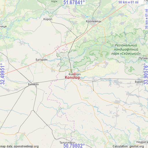
Konotop GPS coordinates[2]
51° 14' 25.152" North, 33° 12' 9.468" East
| Map corner | latitude | longitude |
|---|---|---|
| Upper-left | 51.67841°, | 32.49951° |
| Center: | 51.24032°, | 33.20263° |
| Lower-right: | 50.79802°, | 33.90576° |
| Map W x H: | 97.9×97.9 km | = 60.8×60.8mi |
| max Lat: | 52.18903° ⇑2.9% North |
| Konotop: | 51.24032° |
| min Lat: | ⇓97.1% South 44.39214° |
| min Long | Konotop | max Long |
| 22.20555° | 33.20263° | 40.13222° |
| W 48.5%⇐ | ⇒51.5% E |
Elevation
Elevation of Konotop is 142 m = 466 ft, and this is 13.8 m = 45 ft below average elevation for this country.
| Max E: |
886 m = 2907 ft | 47.8% |
| Avg. | 155.8 m = 511 ft | |
| Konotop | 142 m = 466 ft | |
Min E: |
-3 m = -10 ft | 52.2% |
See also: Konotop elevation on elevation.city.
Geographical zone
Konotop is located in North temperate zone (between Tropic of Cancer and the Arctic Circle). Distance of this North polar circle is 1703.8 km =1058.7 mi to North.| Distance of | km | miles | from Konotop |
|---|---|---|---|
| North Pole | 4309.7 | 2677.9 | to North |
| Arctic Circle | 1703.8 | 1058.7 | to North |
| Tropic Cancer | 3091.5 | 1921 | to South |
| Equator | 5697.4 | 3540.2 | to South |


Nearby cities:
15 places around Konotop: (largest is in red/bold)
• Avdiyivka
65.8 km =40.9 mi,  334°
334°
• Bakhmach
26.5 km =16.5 mi,  255°
255°
• Bakhmach
30.1 km =18.7 mi, 261°
• Baturyn
25.4 km =15.8 mi,  297°
297°
• Borzna
54 km =33.6 mi,  271°
271°
• Buryn’
44.3 km =27.5 mi,  95°
95°
• Korop
40 km =24.9 mi, 334°
• Krolevets’
36.4 km =22.6 mi,  20°
20°
• Nedryhayliv
65.3 km =40.6 mi,  133°
133°
• Putyvl’
47.7 km =29.6 mi,  76°
76°
• Romny
57.6 km =35.8 mi,  160°
160°
• Sloboda
28.5 km =17.7 mi, 99°
• Sosnytsya
58.1 km =36.1 mi, 302°
• Talalayivka
44.8 km =27.8 mi,  185°
185°
• Terny
60.4 km =37.5 mi,  117°
117°
Sources, notices
• [Note1] Compared only with cities in Ukraine existing in our database
• [Src1] Map data: © OpenStreetMap contributors (CC-BY-SA)
• [Src2] Other city data from geonames.org with taken over terms of usage.
• [Src3] Geographical zone / Annual Mean Temperature by Robert A. Rohde @ Wikipedia
