Shalyhyne geodata
Shalyhyne (Sumy) is a populated place; located in Ukraine in Europe/Kiev (GMT+3) time zone. With population of 3,031 people, there are 936 cities with bigger population in this country. Compared to other cities in Ukraine, 98.4% of cities are located further ↓South; 65.8% of cities are located further ←West and 57.8% of cities have lower elevation than Shalyhyne. Note1


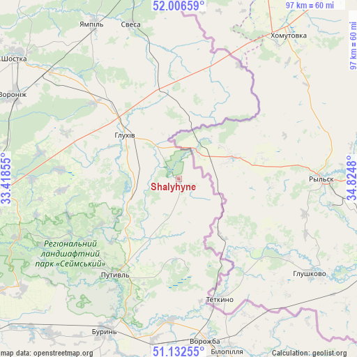
Shalyhyne GPS coordinates[2]
51° 34' 18.012" North, 34° 7' 18.012" East
| Map corner | latitude | longitude |
|---|---|---|
| Upper-left | 52.00659°, | 33.41855° |
| Center: | 51.57167°, | 34.12167° |
| Lower-right: | 51.13255°, | 34.8248° |
| Map W x H: | 97.2×97.2 km | = 60.4×60.4mi |
| max Lat: | 52.18903° ⇑1.6% North |
| Shalyhyne: | 51.57167° |
| min Lat: | ⇓98.4% South 44.39214° |
| min Long | Shalyhyne | max Long |
| 22.20555° | 34.12167° | 40.13222° |
| W 65.8%⇐ | ⇒34.2% E |
Elevation
Elevation of Shalyhyne is 160 m = 525 ft, and this is 4.2 m = 14 ft above average elevation for this country.
| Max E: |
886 m = 2907 ft | 42.2% |
| Shalyhyne | 160 m 525 ft | |
| Avg. | 155.8 m = 511 ft | |
Min E: |
-3 m = -10 ft | 57.8% |
See also: Ukraine elevation on elevation.city.
Geographical zone
Shalyhyne is located in North temperate zone (between Tropic of Cancer and the Arctic Circle). Distance of this North polar circle is 1666.9 km =1035.8 mi to North.| Distance of | km | miles | from Shalyhyne |
|---|---|---|---|
| North Pole | 4272.8 | 2655 | to North |
| Arctic Circle | 1666.9 | 1035.8 | to North |
| Tropic Cancer | 3128.3 | 1943.8 | to South |
| Equator | 5734.2 | 3563.1 | to South |


Nearby cities:
15 places around Shalyhyne: (largest is in red/bold)
• Bilopillya
48.7 km =30.3 mi,  164°
164°
• Buryn’
45.9 km =28.5 mi,  205°
205°
• Chuykivka
51.7 km =32.1 mi,  350°
350°
• Druzhba
54.1 km =33.6 mi, 347°
• Hlukhiv
18.5 km =11.5 mi,  309°
309°
• Konotop
73.6 km =45.7 mi,  239°
239°
• Krolevets’
51 km =31.7 mi,  267°
267°
• Putyvl’
31.3 km =19.4 mi, 213°
• Seredyna-Buda
68.9 km =42.8 mi,  355°
355°
• Shostka
55.4 km =34.4 mi, 305°
• Sloboda
54.8 km =34.1 mi,  220°
220°
• Terny
65.6 km =40.8 mi,  189°
189°
• Vorozhba
44.8 km =27.8 mi,  171°
171°
• Yampil’
47.7 km =29.6 mi,  331°
331°
• Yesman’
22.4 km =13.9 mi, 350°
Sources, notices
• [Note1] Compared only with cities in Ukraine existing in our database
• [Src1] Map data: © OpenStreetMap contributors (CC-BY-SA)
• [Src2] Other city data from geonames.org with taken over terms of usage.
• [Src3] Geographical zone / Annual Mean Temperature by Robert A. Rohde @ Wikipedia
