Putyvl’ geodata
Putyvl’ (Sumy) is a seat of a second-order administrative division; located in Ukraine in Europe/Kiev (GMT+3) time zone. With population of 20,000 people, there are 200 cities with bigger population in this country. Compared to other cities in Ukraine, 97.4% of cities are located further ↓South; 59.6% of cities are located further ←West and 64.6% of cities have lower elevation than Putyvl’. Note1


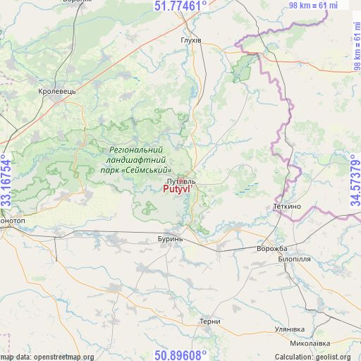
Putyvl’ GPS coordinates[2]
51° 20' 14.82" North, 33° 52' 14.376" East
| Map corner | latitude | longitude |
|---|---|---|
| Upper-left | 51.77461°, | 33.16754° |
| Center: | 51.33745°, | 33.87066° |
| Lower-right: | 50.89608°, | 34.57379° |
| Map W x H: | 97.7×97.7 km | = 60.7×60.7mi |
| max Lat: | 52.18903° ⇑2.6% North |
| Putyvl’: | 51.33745° |
| min Lat: | ⇓97.4% South 44.39214° |
| min Long | Putyvl’ | max Long |
| 22.20555° | 33.87066° | 40.13222° |
| W 59.6%⇐ | ⇒40.4% E |
Elevation
Elevation of Putyvl’ is 184 m = 604 ft, and this is 28.2 m = 93 ft above average elevation for this country.
| Max E: |
886 m = 2907 ft | 35.4% |
| Putyvl’ | 184 m 604 ft | |
| Avg. | 155.8 m = 511 ft | |
Min E: |
-3 m = -10 ft | 64.6% |
See also: Ukraine elevation on elevation.city.
Geographical zone
Putyvl’ is located in North temperate zone (between Tropic of Cancer and the Arctic Circle). Distance of this North polar circle is 1693 km =1052 mi to North.| Distance of | km | miles | from Putyvl’ |
|---|---|---|---|
| North Pole | 4298.9 | 2671.2 | to North |
| Arctic Circle | 1693 | 1052 | to North |
| Tropic Cancer | 3102.3 | 1927.7 | to South |
| Equator | 5708.2 | 3546.9 | to South |


Nearby cities:
15 places around Putyvl’: (largest is in red/bold)
• Baturyn
69 km =42.9 mi,  270°
270°
• Bilopillya
37.2 km =23.1 mi,  124°
124°
• Buryn’
15.6 km =9.7 mi,  189°
189°
• Hlukhiv
38 km =23.6 mi,  4°
4°
• Konotop
47.7 km =29.6 mi,  256°
256°
• Korop
68.1 km =42.3 mi,  291°
291°
• Krolevets’
41 km =25.5 mi,  304°
304°
• Nedryhayliv
56 km =34.8 mi,  179°
179°
• Shalyhyne
31.3 km =19.4 mi,  33°
33°
• Shostka
64.7 km =40.2 mi,  334°
334°
• Sloboda
24 km =14.9 mi,  229°
229°
• Terny
39.3 km =24.4 mi,  169°
169°
• Vorozhba
30.4 km =18.9 mi,  126°
126°
• Yampil’
68.1 km =42.3 mi,  355°
355°
• Yesman’
50 km =31.1 mi,  15°
15°
Sources, notices
• [Note1] Compared only with cities in Ukraine existing in our database
• [Src1] Map data: © OpenStreetMap contributors (CC-BY-SA)
• [Src2] Other city data from geonames.org with taken over terms of usage.
• [Src3] Geographical zone / Annual Mean Temperature by Robert A. Rohde @ Wikipedia
