Hlukhiv geodata
Hlukhiv (Sumy) is a seat of a second-order administrative division; located in Ukraine in Europe/Kiev (GMT+3) time zone. With population of 35,387 people, there are 125 cities with bigger population in this country. Compared to other cities in Ukraine, 98.9% of cities are located further ↓South; 60.4% of cities are located further ←West and 60.1% of cities have lower elevation than Hlukhiv. Note1


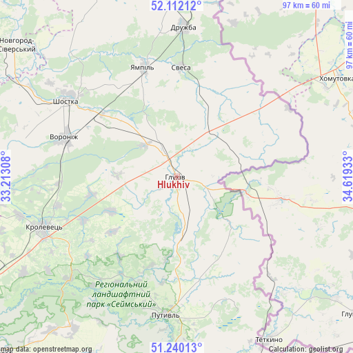
Hlukhiv GPS coordinates[2]
51° 40' 41.592" North, 33° 54' 58.32" East
| Map corner | latitude | longitude |
|---|---|---|
| Upper-left | 52.11212°, | 33.21308° |
| Center: | 51.67822°, | 33.9162° |
| Lower-right: | 51.24013°, | 34.61933° |
| Map W x H: | 97×97 km | = 60.3×60.3mi |
| max Lat: | 52.18903° ⇑1.1% North |
| Hlukhiv: | 51.67822° |
| min Lat: | ⇓98.9% South 44.39214° |
| min Long | Hlukhiv | max Long |
| 22.20555° | 33.9162° | 40.13222° |
| W 60.4%⇐ | ⇒39.6% E |
Elevation
Elevation of Hlukhiv is 169 m = 554 ft, and this is 13.2 m = 43 ft above average elevation for this country.
| Max E: |
886 m = 2907 ft | 39.9% |
| Hlukhiv | 169 m 554 ft | |
| Avg. | 155.8 m = 511 ft | |
Min E: |
-3 m = -10 ft | 60.1% |
See also: Ukraine elevation on elevation.city.
Geographical zone
Hlukhiv is located in North temperate zone (between Tropic of Cancer and the Arctic Circle). Distance of this North polar circle is 1655.1 km =1028.4 mi to North.| Distance of | km | miles | from Hlukhiv |
|---|---|---|---|
| North Pole | 4261 | 2647.7 | to North |
| Arctic Circle | 1655.1 | 1028.4 | to North |
| Tropic Cancer | 3140.2 | 1951.2 | to South |
| Equator | 5746.1 | 3570.5 | to South |


Nearby cities:
15 places around Hlukhiv: (largest is in red/bold)
• Bilopillya
64.8 km =40.3 mi,  154°
154°
• Buryn’
53.6 km =33.3 mi,  186°
186°
• Chuykivka
39.7 km =24.7 mi,  8°
8°
• Druzhba
40.9 km =25.4 mi,  2°
2°
• Korop
67.3 km =41.8 mi,  259°
259°
• Krolevets’
39.5 km =24.5 mi,  248°
248°
• Novhorod-Sivers’kyy
57.9 km =36 mi,  308°
308°
• Putyvl’
38 km =23.6 mi,  184°
184°
• Seredyna-Buda
57.4 km =35.7 mi, 8°
• Shalyhyne
18.5 km =11.5 mi,  129°
129°
• Shostka
37 km =23 mi,  303°
303°
• Sloboda
57.5 km =35.7 mi,  201°
201°
• Vorozhba
59.9 km =37.2 mi,  159°
159°
• Yampil’
31.2 km =19.4 mi,  343°
343°
• Yesman’
14.6 km =9.1 mi,  45°
45°
In other languages:
- In Spanish: Hlújiv
- In France: Hloukhiv
- In German: Hluchiw
- In Russian: Глухів
- In Chinese: 格盧霍夫
Sources, notices
• [Note1] Compared only with cities in Ukraine existing in our database
• [Src1] Map data: © OpenStreetMap contributors (CC-BY-SA)
• [Src2] Other city data from geonames.org with taken over terms of usage.
• [Src3] Geographical zone / Annual Mean Temperature by Robert A. Rohde @ Wikipedia
