Seredyna-Buda geodata
Seredyna-Buda (Sumy) is a seat of a second-order administrative division; located in Ukraine in Europe/Kiev (GMT+3) time zone. With population of 7,161 people, there are 497 cities with bigger population in this country. Compared to other cities in Ukraine, 100% of cities are located further ↓South; 63.7% of cities are located further ←West and 67.1% of cities have lower elevation than Seredyna-Buda. Note1


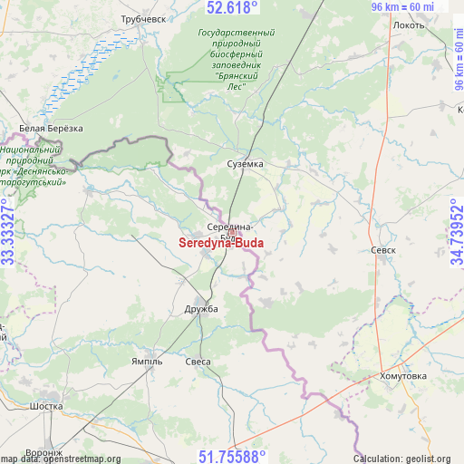
Seredyna-Buda GPS coordinates[2]
52° 11' 20.508" North, 34° 2' 11.004" East
| Map corner | latitude | longitude |
|---|---|---|
| Upper-left | 52.618°, | 33.33327° |
| Center: | 52.18903°, | 34.03639° |
| Lower-right: | 51.75588°, | 34.73952° |
| Map W x H: | 95.9×95.9 km | = 59.6×59.6mi |
| max Lat: | 52.18903° ⇑0% North |
| Seredyna-Buda: | 52.18903° |
| min Lat: | ⇓100% South 44.39214° |
| min Long | Seredyna-Buda | max Long |
| 22.20555° | 34.03639° | 40.13222° |
| W 63.7%⇐ | ⇒36.3% E |
Elevation
Elevation of Seredyna-Buda is 194 m = 636 ft, and this is 38.2 m = 125 ft above average elevation for this country.
| Max E: |
886 m = 2907 ft | 32.9% |
| Seredyna-Buda | 194 m 636 ft | |
| Avg. | 155.8 m = 511 ft | |
Min E: |
-3 m = -10 ft | 67.1% |
See also: Ukraine elevation on elevation.city.
Geographical zone
Seredyna-Buda is located in North temperate zone (between Tropic of Cancer and the Arctic Circle). Distance of this North polar circle is 1598.3 km =993.1 mi to North.| Distance of | km | miles | from Seredyna-Buda |
|---|---|---|---|
| North Pole | 4204.2 | 2612.4 | to North |
| Arctic Circle | 1598.3 | 993.1 | to North |
| Tropic Cancer | 3197 | 1986.5 | to South |
| Equator | 5802.9 | 3605.8 | to South |


Nearby cities:
15 places around Seredyna-Buda: (largest is in red/bold)
• Avdiyivka
96.3 km =59.8 mi,  241°
241°
• Buryn’
110.9 km =68.9 mi,  187°
187°
• Chuykivka
17.7 km =11 mi, 187°
• Druzhba
17.1 km =10.6 mi,  201°
201°
• Hlukhiv
57.4 km =35.7 mi, 188°
• Kholmy
104.4 km =64.9 mi,  250°
250°
• Korop
101.3 km =62.9 mi,  226°
226°
• Krolevets’
84.2 km =52.3 mi,  212°
212°
• Novhorod-Sivers’kyy
56.7 km =35.2 mi, 248°
• Putyvl’
95.4 km =59.3 mi, 186°
• Semenivka
99.2 km =61.6 mi,  269°
269°
• Shalyhyne
68.9 km =42.8 mi,  175°
175°
• Shostka
53.1 km =33 mi, 226°
• Yampil’
31.8 km =19.8 mi, 212°
• Yesman’
46.6 km =29 mi, 177°
Sources, notices
• [Note1] Compared only with cities in Ukraine existing in our database
• [Src1] Map data: © OpenStreetMap contributors (CC-BY-SA)
• [Src2] Other city data from geonames.org with taken over terms of usage.
• [Src3] Geographical zone / Annual Mean Temperature by Robert A. Rohde @ Wikipedia
