Yampil’ geodata
Yampil’ (Sumy) is a populated place; located in Ukraine in Europe/Kiev (GMT+3) time zone. With population of 7,200 people, there are 496 cities with bigger population in this country. Compared to other cities in Ukraine, 99.6% of cities are located further ↓South; 57.5% of cities are located further ←West and 56.6% of cities have lower elevation than Yampil’. Note1


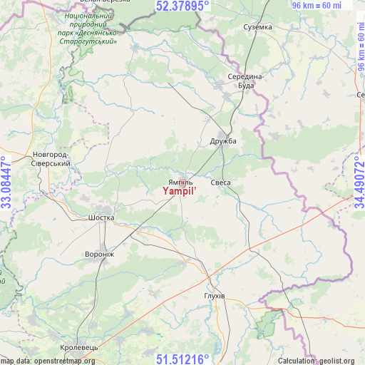
Yampil’ GPS coordinates[2]
51° 56' 51.54" North, 33° 47' 15.324" East
| Map corner | latitude | longitude |
|---|---|---|
| Upper-left | 52.37895°, | 33.08447° |
| Center: | 51.94765°, | 33.78759° |
| Lower-right: | 51.51216°, | 34.49072° |
| Map W x H: | 96.4×96.4 km | = 59.9×59.9mi |
| max Lat: | 52.18903° ⇑0.4% North |
| Yampil’: | 51.94765° |
| min Lat: | ⇓99.6% South 44.39214° |
| min Long | Yampil’ | max Long |
| 22.20555° | 33.78759° | 40.13222° |
| W 57.5%⇐ | ⇒42.5% E |
Elevation
Elevation of Yampil’ is 157 m = 515 ft, and this is 1.2 m = 4 ft above average elevation for this country.
| Max E: |
886 m = 2907 ft | 43.4% |
| Yampil’ | 157 m 515 ft | |
| Avg. | 155.8 m = 511 ft | |
Min E: |
-3 m = -10 ft | 56.6% |
See also: Ukraine elevation on elevation.city.
Geographical zone
Yampil’ is located in North temperate zone (between Tropic of Cancer and the Arctic Circle). Distance of this North polar circle is 1625.1 km =1009.8 mi to North.| Distance of | km | miles | from Yampil’ |
|---|---|---|---|
| North Pole | 4231 | 2629 | to North |
| Arctic Circle | 1625.1 | 1009.8 | to North |
| Tropic Cancer | 3170.1 | 1969.8 | to South |
| Equator | 5776 | 3589 | to South |


Nearby cities:
15 places around Yampil’: (largest is in red/bold)
• Avdiyivka
70.4 km =43.7 mi,  254°
254°
• Buryn’
83.3 km =51.8 mi,  177°
177°
• Chuykivka
17.4 km =10.8 mi,  57°
57°
• Druzhba
15.3 km =9.5 mi,  44°
44°
• Hlukhiv
31.2 km =19.4 mi,  163°
163°
• Kholmy
81.9 km =50.9 mi,  264°
264°
• Korop
71.1 km =44.2 mi,  233°
233°
• Krolevets’
52.4 km =32.6 mi,  211°
211°
• Novhorod-Sivers’kyy
36.6 km =22.7 mi,  280°
280°
• Putyvl’
68.1 km =42.3 mi, 175°
• Seredyna-Buda
31.8 km =19.8 mi,  32°
32°
• Shalyhyne
47.7 km =29.6 mi,  151°
151°
• Shostka
23.7 km =14.7 mi, 246°
• Sloboda
84.3 km =52.4 mi,  188°
188°
• Yesman’
27.5 km =17.1 mi,  135°
135°
Sources, notices
• [Note1] Compared only with cities in Ukraine existing in our database
• [Src1] Map data: © OpenStreetMap contributors (CC-BY-SA)
• [Src2] Other city data from geonames.org with taken over terms of usage.
• [Src3] Geographical zone / Annual Mean Temperature by Robert A. Rohde @ Wikipedia
