Nizhyn geodata
Nizhyn (Chernihiv) is a seat of a second-order administrative division; located in Ukraine in Europe/Kiev (GMT+3) time zone. With population of 75,499 people, there are 61 cities with bigger population in this country. Compared to other cities in Ukraine, 95.8% of cities are located further ↓South; 57.8% of cities are located further →East and 51.8% of cities have higher elevation than Nizhyn. Note1


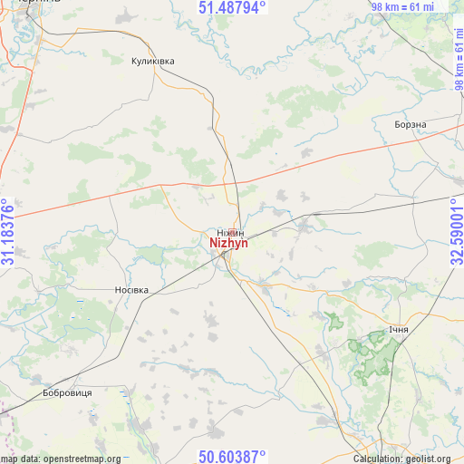
Nizhyn GPS coordinates[2]
51° 2' 52.836" North, 31° 53' 12.768" East
| Map corner | latitude | longitude |
|---|---|---|
| Upper-left | 51.48794°, | 31.18376° |
| Center: | 51.04801°, | 31.88688° |
| Lower-right: | 50.60387°, | 32.59001° |
| Map W x H: | 98.3×98.3 km | = 61.1×61.1mi |
| max Lat: | 52.18903° ⇑4.2% North |
| Nizhyn: | 51.04801° |
| min Lat: | ⇓95.8% South 44.39214° |
| min Long | Nizhyn | max Long |
| 22.20555° | 31.88688° | 40.13222° |
| W 42.2%⇐ | ⇒57.8% E |
Elevation
Elevation of Nizhyn is 128 m = 420 ft, and this is 27.8 m = 91 ft below average elevation for this country.
| Max E: |
886 m = 2907 ft | 51.8% |
| Avg. | 155.8 m = 511 ft | |
| Nizhyn | 128 m = 420 ft | |
Min E: |
-3 m = -10 ft | 48.2% |
See also: Nizhyn elevation on elevation.city.
Geographical zone
Nizhyn is located in North temperate zone (between Tropic of Cancer and the Arctic Circle). Distance of this North polar circle is 1725.2 km =1072 mi to North.| Distance of | km | miles | from Nizhyn |
|---|---|---|---|
| North Pole | 4331.1 | 2691.2 | to North |
| Arctic Circle | 1725.2 | 1072 | to North |
| Tropic Cancer | 3070.1 | 1907.7 | to South |
| Equator | 5676 | 3526.9 | to South |


Nearby cities:
15 places around Nizhyn: (largest is in red/bold)
• Berezna
58.7 km =36.5 mi,  353°
353°
• Bobrovytsya
48.1 km =29.9 mi,  225°
225°
• Borzna
44.1 km =27.4 mi,  58°
58°
• Druzhba
42.9 km =26.7 mi,  129°
129°
• Ichnya
41.1 km =25.5 mi,  120°
120°
• Kobyzhcha
36.2 km =22.5 mi, 227°
• Kozelets’
55.6 km =34.5 mi,  254°
254°
• Kruty
15.4 km =9.6 mi,  85°
85°
• Kulykivka
39.9 km =24.8 mi,  335°
335°
• Kunashëvka
8.9 km =5.5 mi, 94°
• Lisovi Sorochyntsi
50.5 km =31.4 mi,  142°
142°
• Mena
57.4 km =35.7 mi,  23°
23°
• Nosivka
24.9 km =15.5 mi,  238°
238°
• Olyshivka
43.2 km =26.8 mi,  296°
296°
• Talalayivka
10.3 km =6.4 mi,  166°
166°
Sources, notices
• [Note1] Compared only with cities in Ukraine existing in our database
• [Src1] Map data: © OpenStreetMap contributors (CC-BY-SA)
• [Src2] Other city data from geonames.org with taken over terms of usage.
• [Src3] Geographical zone / Annual Mean Temperature by Robert A. Rohde @ Wikipedia
