Orzhytsya geodata
Orzhytsya (Poltava) is a seat of a second-order administrative division; located in Ukraine in Europe/Kiev (GMT+3) time zone. With population of 3,898 people, there are 772 cities with bigger population in this country. Compared to other cities in Ukraine, 79.2% of cities are located further ↓South; 54.2% of cities are located further →East and 62.4% of cities have higher elevation than Orzhytsya. Note1


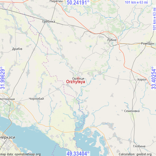
Orzhytsya GPS coordinates[2]
49° 47' 24.36" North, 32° 41' 57.876" East
| Map corner | latitude | longitude |
|---|---|---|
| Upper-left | 50.24191°, | 31.99629° |
| Center: | 49.7901°, | 32.69941° |
| Lower-right: | 49.33404°, | 33.40254° |
| Map W x H: | 100.9×100.9 km | = 62.7×62.7mi |
| max Lat: | 52.18903° ⇑20.8% North |
| Orzhytsya: | 49.7901° |
| min Lat: | ⇓79.2% South 44.39214° |
| min Long | Orzhytsya | max Long |
| 22.20555° | 32.69941° | 40.13222° |
| W 45.8%⇐ | ⇒54.2% E |
Elevation
Elevation of Orzhytsya is 99 m = 325 ft, and this is 56.8 m = 186 ft below average elevation for this country.
| Max E: |
886 m = 2907 ft | 62.4% |
| Avg. | 155.8 m = 511 ft | |
| Orzhytsya | 99 m = 325 ft | |
Min E: |
-3 m = -10 ft | 37.6% |
See also: Ukraine elevation on elevation.city.
Geographical zone
Orzhytsya is located in North temperate zone (between Tropic of Cancer and the Arctic Circle). Distance of this North polar circle is 1865 km =1158.9 mi to North.| Distance of | km | miles | from Orzhytsya |
|---|---|---|---|
| North Pole | 4470.9 | 2778.1 | to North |
| Arctic Circle | 1865 | 1158.9 | to North |
| Tropic Cancer | 2930.2 | 1820.7 | to South |
| Equator | 5536.1 | 3440 | to South |


Nearby cities:
15 places around Orzhytsya: (largest is in red/bold)
• Bogdanivka
68.3 km =42.4 mi,  314°
314°
• Cherkasy
61 km =37.9 mi,  228°
228°
• Chervona Sloboda
60.7 km =37.7 mi,  220°
220°
• Chornobay
29.9 km =18.6 mi,  242°
242°
• Chornukhy
55.8 km =34.7 mi,  18°
18°
• Drabiv
44.3 km =27.5 mi,  295°
295°
• Hlobyne
60.3 km =37.5 mi,  137°
137°
• Hrebinka
41 km =25.5 mi,  332°
332°
• Khorol
41.6 km =25.8 mi,  90°
90°
• Lubny
33 km =20.5 mi,  40°
40°
• Myrhorod
68.1 km =42.3 mi,  73°
73°
• Pyryatyn
52.2 km =32.4 mi,  344°
344°
• Romodan
50.1 km =31.1 mi,  63°
63°
• Semenivka
41.1 km =25.5 mi,  122°
122°
• Zolotonosha
49.3 km =30.6 mi,  254°
254°
Sources, notices
• [Note1] Compared only with cities in Ukraine existing in our database
• [Src1] Map data: © OpenStreetMap contributors (CC-BY-SA)
• [Src2] Other city data from geonames.org with taken over terms of usage.
• [Src3] Geographical zone / Annual Mean Temperature by Robert A. Rohde @ Wikipedia
