Romodan geodata
Romodan (Poltava) is a populated place; located in Ukraine in Europe/Kiev (GMT+3) time zone. With population of 3,225 people, there are 881 cities with bigger population in this country. Compared to other cities in Ukraine, 83.7% of cities are located further ↓South; 50% of cities are located further ←West and 54.6% of cities have lower elevation than Romodan. Note1


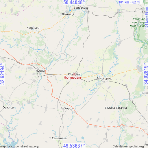
Romodan GPS coordinates[2]
49° 59' 25.98" North, 33° 19' 30.216" East
| Map corner | latitude | longitude |
|---|---|---|
| Upper-left | 50.44048°, | 32.62194° |
| Center: | 49.99055°, | 33.32506° |
| Lower-right: | 49.53637°, | 34.02819° |
| Map W x H: | 100.5×100.5 km | = 62.4×62.4mi |
| max Lat: | 52.18903° ⇑16.3% North |
| Romodan: | 49.99055° |
| min Lat: | ⇓83.7% South 44.39214° |
| min Long | Romodan | max Long |
| 22.20555° | 33.32506° | 40.13222° |
| W 50%⇐ | ⇒50% E |
Elevation
Elevation of Romodan is 151 m = 495 ft, and this is 4.8 m = 16 ft below average elevation for this country.
| Max E: |
886 m = 2907 ft | 45.4% |
| Avg. | 155.8 m = 511 ft | |
| Romodan | 151 m = 495 ft | |
Min E: |
-3 m = -10 ft | 54.6% |
See also: Ukraine elevation on elevation.city.
Geographical zone
Romodan is located in North temperate zone (between Tropic of Cancer and the Arctic Circle). Distance of this North polar circle is 1842.7 km =1145 mi to North.| Distance of | km | miles | from Romodan |
|---|---|---|---|
| North Pole | 4448.6 | 2764.2 | to North |
| Arctic Circle | 1842.7 | 1145 | to North |
| Tropic Cancer | 2952.5 | 1834.6 | to South |
| Equator | 5558.4 | 3453.8 | to South |


Nearby cities:
15 places around Romodan: (largest is in red/bold)
• Chornukhy
41.1 km =25.5 mi,  318°
318°
• Hadyach
63.6 km =39.5 mi,  48°
48°
• Hrebinka
65 km =40.4 mi,  282°
282°
• Khorol
23.2 km =14.4 mi,  188°
188°
• Komyshnya
33.3 km =20.7 mi, 49°
• Lokhvytsya
42.2 km =26.2 mi,  353°
353°
• Lubny
23.6 km =14.7 mi, 276°
• Myrhorod
20.4 km =12.7 mi,  96°
96°
• Orzhytsya
50.1 km =31.1 mi,  243°
243°
• Pyryatyn
64.8 km =40.3 mi,  295°
295°
• Semenivka
45.7 km =28.4 mi, 193°
• Sencha
29.4 km =18.3 mi,  2°
2°
• Shyshaky
50.6 km =31.4 mi, 103°
• Velyka Bahachka
36.1 km =22.4 mi,  127°
127°
• Velyki Sorochyntsi
44.2 km =27.5 mi,  85°
85°
Sources, notices
• [Note1] Compared only with cities in Ukraine existing in our database
• [Src1] Map data: © OpenStreetMap contributors (CC-BY-SA)
• [Src2] Other city data from geonames.org with taken over terms of usage.
• [Src3] Geographical zone / Annual Mean Temperature by Robert A. Rohde @ Wikipedia
