Chornobay geodata
Chornobay (Cherkasy) is a seat of a second-order administrative division; located in Ukraine in Europe/Kiev (GMT+3) time zone. With population of 8,053 people, there are 439 cities with bigger population in this country. Compared to other cities in Ukraine, 77.5% of cities are located further ↓South; 56.1% of cities are located further →East and 56.5% of cities have higher elevation than Chornobay. Note1


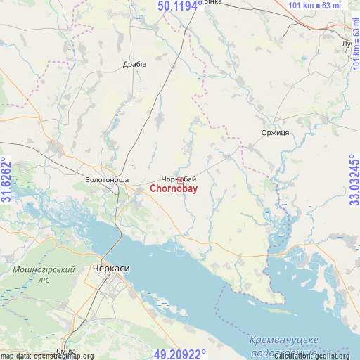
Chornobay GPS coordinates[2]
49° 39' 59.184" North, 32° 19' 45.552" East
| Map corner | latitude | longitude |
|---|---|---|
| Upper-left | 50.1194°, | 31.6262° |
| Center: | 49.66644°, | 32.32932° |
| Lower-right: | 49.20922°, | 33.03245° |
| Map W x H: | 101.2×101.2 km | = 62.9×62.9mi |
| max Lat: | 52.18903° ⇑22.5% North |
| Chornobay: | 49.66644° |
| min Lat: | ⇓77.5% South 44.39214° |
| min Long | Chornobay | max Long |
| 22.20555° | 32.32932° | 40.13222° |
| W 43.9%⇐ | ⇒56.1% E |
Elevation
Elevation of Chornobay is 116 m = 381 ft, and this is 39.8 m = 131 ft below average elevation for this country.
| Max E: |
886 m = 2907 ft | 56.5% |
| Avg. | 155.8 m = 511 ft | |
| Chornobay | 116 m = 381 ft | |
Min E: |
-3 m = -10 ft | 43.5% |
See also: Ukraine elevation on elevation.city.
Geographical zone
Chornobay is located in North temperate zone (between Tropic of Cancer and the Arctic Circle). Distance of this North polar circle is 1878.8 km =1167.4 mi to North.| Distance of | km | miles | from Chornobay |
|---|---|---|---|
| North Pole | 4484.7 | 2786.7 | to North |
| Arctic Circle | 1878.8 | 1167.4 | to North |
| Tropic Cancer | 2916.5 | 1812.2 | to South |
| Equator | 5522.4 | 3431.5 | to South |


Nearby cities:
15 places around Chornobay: (largest is in red/bold)
• Bogdanivka
65.3 km =40.6 mi,  339°
339°
• Cherkasy
32.7 km =20.3 mi,  216°
216°
• Chervona Sloboda
34.9 km =21.7 mi,  200°
200°
• Drabiv
35.4 km =22 mi, 337°
• Hrebinka
50.7 km =31.5 mi,  8°
8°
• Kaniv
63.2 km =39.3 mi,  278°
278°
• Lubny
61.7 km =38.3 mi,  50°
50°
• Moshny
45.4 km =28.2 mi,  250°
250°
• Orzhytsya
29.9 km =18.6 mi,  62°
62°
• Pyryatyn
65.3 km =40.6 mi, 11°
• Ruska Poliana
40.5 km =25.2 mi,  226°
226°
• Semenivka
61.9 km =38.5 mi,  97°
97°
• Smila
58.8 km =36.5 mi,  212°
212°
• Tsybli
66 km =41 mi,  303°
303°
• Zolotonosha
20.8 km =12.9 mi,  270°
270°
Sources, notices
• [Note1] Compared only with cities in Ukraine existing in our database
• [Src1] Map data: © OpenStreetMap contributors (CC-BY-SA)
• [Src2] Other city data from geonames.org with taken over terms of usage.
• [Src3] Geographical zone / Annual Mean Temperature by Robert A. Rohde @ Wikipedia
