Myrhorod geodata
Myrhorod (Poltava) is a seat of a second-order administrative division; located in Ukraine in Europe/Kiev (GMT+3) time zone. With population of 41,377 people, there are 109 cities with bigger population in this country. Compared to other cities in Ukraine, 83.1% of cities are located further ↓South; 53.4% of cities are located further ←West and 62.1% of cities have higher elevation than Myrhorod. Note1


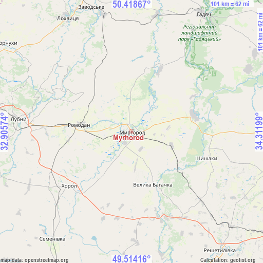
Myrhorod GPS coordinates[2]
49° 58' 6.744" North, 33° 36' 31.896" East
| Map corner | latitude | longitude |
|---|---|---|
| Upper-left | 50.41867°, | 32.90574° |
| Center: | 49.96854°, | 33.60886° |
| Lower-right: | 49.51416°, | 34.31199° |
| Map W x H: | 100.6×100.6 km | = 62.5×62.5mi |
| max Lat: | 52.18903° ⇑16.9% North |
| Myrhorod: | 49.96854° |
| min Lat: | ⇓83.1% South 44.39214° |
| min Long | Myrhorod | max Long |
| 22.20555° | 33.60886° | 40.13222° |
| W 53.4%⇐ | ⇒46.6% E |
Elevation
Elevation of Myrhorod is 100 m = 328 ft, and this is 55.8 m = 183 ft below average elevation for this country.
| Max E: |
886 m = 2907 ft | 62.1% |
| Avg. | 155.8 m = 511 ft | |
| Myrhorod | 100 m = 328 ft | |
Min E: |
-3 m = -10 ft | 37.9% |
See also: Myrhorod elevation on elevation.city.
Geographical zone
Myrhorod is located in North temperate zone (between Tropic of Cancer and the Arctic Circle). Distance of this North polar circle is 1845.2 km =1146.6 mi to North.| Distance of | km | miles | from Myrhorod |
|---|---|---|---|
| North Pole | 4451.1 | 2765.8 | to North |
| Arctic Circle | 1845.2 | 1146.6 | to North |
| Tropic Cancer | 2950.1 | 1833.1 | to South |
| Equator | 5556 | 3452.3 | to South |


Nearby cities:
15 places around Myrhorod: (largest is in red/bold)
• Chornukhy
58 km =36 mi,  304°
304°
• Hadyach
52.4 km =32.6 mi,  31°
31°
• Khorol
31.4 km =19.5 mi,  229°
229°
• Komyshnya
24.5 km =15.2 mi,  12°
12°
• Lokhvytsya
50.9 km =31.6 mi,  330°
330°
• Lubny
44.1 km =27.4 mi,  276°
276°
• Lypova Dolyna
67.6 km =42 mi, 11°
• Reshetylivka
56.1 km =34.9 mi,  143°
143°
• Romodan
20.4 km =12.7 mi, 276°
• Semenivka
52.1 km =32.4 mi,  216°
216°
• Sencha
36.9 km =22.9 mi, 329°
• Shyshaky
30.4 km =18.9 mi,  108°
108°
• Velyka Bahachka
21.3 km =13.2 mi,  157°
157°
• Velyki Sorochyntsi
24.5 km =15.2 mi,  75°
75°
• Zin’kiv
60.1 km =37.3 mi,  63°
63°
Sources, notices
• [Note1] Compared only with cities in Ukraine existing in our database
• [Src1] Map data: © OpenStreetMap contributors (CC-BY-SA)
• [Src2] Other city data from geonames.org with taken over terms of usage.
• [Src3] Geographical zone / Annual Mean Temperature by Robert A. Rohde @ Wikipedia
