Lubny geodata
Lubny (Poltava) is a seat of a second-order administrative division; located in Ukraine in Europe/Kiev (GMT+3) time zone. With population of 52,600 people, there are 89 cities with bigger population in this country. Compared to other cities in Ukraine, 84% of cities are located further ↓South; 52.4% of cities are located further →East and 55.3% of cities have lower elevation than Lubny. Note1


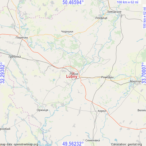
Lubny GPS coordinates[2]
50° 0' 58.5" North, 32° 59' 48.984" East
| Map corner | latitude | longitude |
|---|---|---|
| Upper-left | 50.46594°, | 32.29382° |
| Center: | 50.01625°, | 32.99694° |
| Lower-right: | 49.56232°, | 33.70007° |
| Map W x H: | 100.5×100.5 km | = 62.4×62.4mi |
| max Lat: | 52.18903° ⇑16% North |
| Lubny: | 50.01625° |
| min Lat: | ⇓84% South 44.39214° |
| min Long | Lubny | max Long |
| 22.20555° | 32.99694° | 40.13222° |
| W 47.6%⇐ | ⇒52.4% E |
Elevation
Elevation of Lubny is 153 m = 502 ft, and this is 2.8 m = 9 ft below average elevation for this country.
| Max E: |
886 m = 2907 ft | 44.7% |
| Avg. | 155.8 m = 511 ft | |
| Lubny | 153 m = 502 ft | |
Min E: |
-3 m = -10 ft | 55.3% |
See also: Lubny elevation on elevation.city.
Geographical zone
Lubny is located in North temperate zone (between Tropic of Cancer and the Arctic Circle). Distance of this North polar circle is 1839.9 km =1143.3 mi to North.| Distance of | km | miles | from Lubny |
|---|---|---|---|
| North Pole | 4445.8 | 2762.5 | to North |
| Arctic Circle | 1839.9 | 1143.3 | to North |
| Tropic Cancer | 2955.4 | 1836.4 | to South |
| Equator | 5561.3 | 3455.6 | to South |


Nearby cities:
15 places around Lubny: (largest is in red/bold)
• Chornukhy
28.2 km =17.5 mi,  352°
352°
• Drabiv
61.5 km =38.2 mi,  264°
264°
• Hrebinka
41.6 km =25.8 mi,  285°
285°
• Khorol
32.8 km =20.4 mi,  142°
142°
• Komyshnya
52.3 km =32.5 mi,  69°
69°
• Lokhvytsya
43.3 km =26.9 mi,  25°
25°
• Myrhorod
44.1 km =27.4 mi,  96°
96°
• Orzhytsya
33 km =20.5 mi,  220°
220°
• Pyryatyn
43.1 km =26.8 mi,  305°
305°
• Romodan
23.6 km =14.7 mi, 96°
• Semenivka
49.2 km =30.6 mi,  164°
164°
• Sencha
36.4 km =22.6 mi,  43°
43°
• Varva
56.8 km =35.3 mi,  339°
339°
• Velyka Bahachka
57.7 km =35.9 mi,  115°
115°
• Zhuravka
59.1 km =36.7 mi,  331°
331°
Sources, notices
• [Note1] Compared only with cities in Ukraine existing in our database
• [Src1] Map data: © OpenStreetMap contributors (CC-BY-SA)
• [Src2] Other city data from geonames.org with taken over terms of usage.
• [Src3] Geographical zone / Annual Mean Temperature by Robert A. Rohde @ Wikipedia
