Kostryzhivka geodata
Kostryzhivka (Chernivtsi Oblast') is a populated place; located in Ukraine in Europe/Kiev (GMT+3) time zone. With population of 2,768 people, there are 996 cities with bigger population in this country. Compared to other cities in Ukraine, 58.9% of cities are located further ↓South; 82.7% of cities are located further →East and 57.2% of cities have lower elevation than Kostryzhivka. Note1


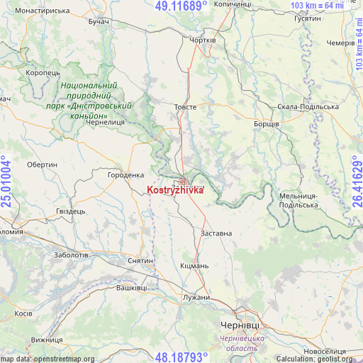
Kostryzhivka GPS coordinates[2]
48° 39' 16.38" North, 25° 42' 47.376" East
| Map corner | latitude | longitude |
|---|---|---|
| Upper-left | 49.11689°, | 25.01004° |
| Center: | 48.65455°, | 25.71316° |
| Lower-right: | 48.18793°, | 26.41629° |
| Map W x H: | 103.3×103.3 km | = 64.2×64.2mi |
| max Lat: | 52.18903° ⇑41.1% North |
| Kostryzhivka: | 48.65455° |
| min Lat: | ⇓58.9% South 44.39214° |
| min Long | Kostryzhivka | max Long |
| 22.20555° | 25.71316° | 40.13222° |
| W 17.3%⇐ | ⇒82.7% E |
Elevation
Elevation of Kostryzhivka is 159 m = 522 ft, and this is 3.2 m = 10 ft above average elevation for this country.
| Max E: |
886 m = 2907 ft | 42.8% |
| Kostryzhivka | 159 m 522 ft | |
| Avg. | 155.8 m = 511 ft | |
Min E: |
-3 m = -10 ft | 57.2% |
See also: Ukraine elevation on elevation.city.
Geographical zone
Kostryzhivka is located in North temperate zone (between Tropic of Cancer and the Arctic Circle). Distance of this North polar circle is 1991.3 km =1237.3 mi to North.| Distance of | km | miles | from Kostryzhivka |
|---|---|---|---|
| North Pole | 4597.2 | 2856.6 | to North |
| Arctic Circle | 1991.3 | 1237.3 | to North |
| Tropic Cancer | 2804 | 1742.3 | to South |
| Equator | 5409.9 | 3361.6 | to South |


Nearby cities:
15 places around Kostryzhivka: (largest is in red/bold)
• Borshchiv
29.3 km =18.2 mi,  55°
55°
• Chernelytsya
27.5 km =17.1 mi,  309°
309°
• Chernyatyn
19.5 km =12.1 mi,  271°
271°
• Horodenka
15.7 km =9.8 mi,  277°
277°
• Kadubivtsi
8.9 km =5.5 mi,  152°
152°
• Kitsman’
23.8 km =14.8 mi,  170°
170°
• Nyrkiv
19.7 km =12.2 mi,  335°
335°
• Shypyntsi
31 km =19.3 mi,  175°
175°
• Sniatyn
25.4 km =15.8 mi,  204°
204°
• Stetseva
17.4 km =10.8 mi,  215°
215°
• Tovste
21.4 km =13.3 mi,  2°
2°
• Verenchanka
12.2 km =7.6 mi, 168°
• Yahil’nytsya
32.1 km =19.9 mi, 4°
• Zalishchyky
2.2 km =1.4 mi,  124°
124°
• Zastavna
17.5 km =10.9 mi, 146°
Sources, notices
• [Note1] Compared only with cities in Ukraine existing in our database
• [Src1] Map data: © OpenStreetMap contributors (CC-BY-SA)
• [Src2] Other city data from geonames.org with taken over terms of usage.
• [Src3] Geographical zone / Annual Mean Temperature by Robert A. Rohde @ Wikipedia
