Nova Odesa geodata
Nova Odesa (Mykolaiv) is a seat of a second-order administrative division; located in Ukraine in Europe/Kiev (GMT+3) time zone. With population of 13,547 people, there are 278 cities with bigger population in this country. Compared to other cities in Ukraine, 62% of cities are located further ↑North; 58% of cities are located further →East and 86.9% of cities have higher elevation than Nova Odesa. Note1


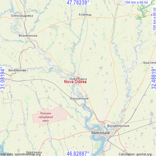
Nova Odesa GPS coordinates[2]
47° 18' 28.008" North, 31° 47' 6.216" East
| Map corner | latitude | longitude |
|---|---|---|
| Upper-left | 47.78239°, | 31.08194° |
| Center: | 47.30778°, | 31.78506° |
| Lower-right: | 46.82887°, | 32.48819° |
| Map W x H: | 106×106 km | = 65.9×65.9mi |
| max Lat: | 52.18903° ⇑62% North |
| Nova Odesa: | 47.30778° |
| min Lat: | ⇓38% South 44.39214° |
| min Long | Nova Odesa | max Long |
| 22.20555° | 31.78506° | 40.13222° |
| W 42%⇐ | ⇒58% E |
Elevation
Elevation of Nova Odesa is 25 m = 82 ft, and this is 130.8 m = 429 ft below average elevation for this country.
| Max E: |
886 m = 2907 ft | 86.9% |
| Avg. | 155.8 m = 511 ft | |
| Nova Odesa | 25 m = 82 ft | |
Min E: |
-3 m = -10 ft | 13.1% |
See also: Ukraine elevation on elevation.city.
Geographical zone
Nova Odesa is located in North temperate zone (between Tropic of Cancer and the Arctic Circle). Distance of this North polar circle is 2141 km =1330.4 mi to North.| Distance of | km | miles | from Nova Odesa |
|---|---|---|---|
| North Pole | 4746.9 | 2949.6 | to North |
| Arctic Circle | 2141 | 1330.4 | to North |
| Tropic Cancer | 2654.2 | 1649.2 | to South |
| Equator | 5260.1 | 3268.5 | to South |


Nearby cities:
15 places around Nova Odesa: (largest is in red/bold)
• Bashtanka
50.5 km =31.4 mi,  77°
77°
• Berezanka
58.9 km =36.6 mi,  210°
210°
• Berezivka
67.2 km =41.8 mi,  260°
260°
• Brats’ke
63.6 km =39.5 mi,  346°
346°
• Domanivka
69.9 km =43.4 mi,  301°
301°
• Kurisove
72.9 km =45.3 mi,  238°
238°
• Mykolayiv
41.3 km =25.7 mi,  157°
157°
• Novyy Buh
70 km =43.5 mi,  52°
52°
• Ol'shanskoye
13.8 km =8.6 mi,  177°
177°
• Parutyne
67.5 km =41.9 mi,  172°
172°
• Shevchenkove
58.8 km =36.5 mi,  147°
147°
• Veselynove
41.8 km =26 mi,  277°
277°
• Voznesensk
44.6 km =27.7 mi,  309°
309°
• Yelanets’
43.6 km =27.1 mi,  6°
6°
• Yuzhnoukrains'k
72.5 km =45 mi,  321°
321°
Sources, notices
• [Note1] Compared only with cities in Ukraine existing in our database
• [Src1] Map data: © OpenStreetMap contributors (CC-BY-SA)
• [Src2] Other city data from geonames.org with taken over terms of usage.
• [Src3] Geographical zone / Annual Mean Temperature by Robert A. Rohde @ Wikipedia
