Bilovods'k geodata
Bilovods'k (Luhansk) is a populated place; located in Ukraine in Europe/Zaporozhye (GMT+3) time zone. With population of 8,626 people, there are 409 cities with bigger population in this country. Compared to other cities in Ukraine, 69.8% of cities are located further ↓South; 99.5% of cities are located further ←West and 74% of cities have higher elevation than Bilovods'k. Note1


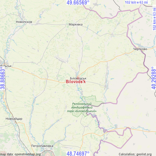
Bilovods'k GPS coordinates[2]
49° 12' 30.456" North, 39° 35' 23.1" East
| Map corner | latitude | longitude |
|---|---|---|
| Upper-left | 49.66569°, | 38.88663° |
| Center: | 49.20846°, | 39.58975° |
| Lower-right: | 48.74697°, | 40.29288° |
| Map W x H: | 102.2×102.2 km | = 63.5×63.5mi |
| max Lat: | 52.18903° ⇑30.2% North |
| Bilovods'k: | 49.20846° |
| min Lat: | ⇓69.8% South 44.39214° |
| min Long | Bilovods'k | max Long |
| 22.20555° | 39.58975° | 40.13222° |
| W 99.5%⇐ | ⇒0.5% E |
Elevation
Elevation of Bilovods'k is 64 m = 210 ft, and this is 91.8 m = 301 ft below average elevation for this country.
| Max E: |
886 m = 2907 ft | 74% |
| Avg. | 155.8 m = 511 ft | |
| Bilovods'k | 64 m = 210 ft | |
Min E: |
-3 m = -10 ft | 26% |
See also: Ukraine elevation on elevation.city.
Geographical zone
Bilovods'k is located in North temperate zone (between Tropic of Cancer and the Arctic Circle). Distance of this North polar circle is 1929.7 km =1199.1 mi to North.| Distance of | km | miles | from Bilovods'k |
|---|---|---|---|
| North Pole | 4535.6 | 2818.3 | to North |
| Arctic Circle | 1929.7 | 1199.1 | to North |
| Tropic Cancer | 2865.5 | 1780.5 | to South |
| Equator | 5471.5 | 3399.8 | to South |


Nearby cities:
15 places around Bilovods'k: (largest is in red/bold)
• Bilokurakyne
72 km =44.7 mi,  300°
300°
• Luhansk
74.1 km =46 mi,  195°
195°
• Makariv Yar
70.8 km =44 mi,  172°
172°
• Markivka
35 km =21.7 mi,  357°
357°
• Met’olkine
81.6 km =50.7 mi,  247°
247°
• Milove
43.5 km =27 mi,  64°
64°
• Novoaydar
50.5 km =31.4 mi,  237°
237°
• Novopskov
52.2 km =32.4 mi,  316°
316°
• Pavlivka
77.7 km =48.3 mi, 304°
• Shchastya
58.3 km =36.2 mi,  206°
206°
• Slov`yanoserbsk
72.1 km =44.8 mi,  218°
218°
• Stanytsya Luhans’ka
62.1 km =38.6 mi,  187°
187°
• Starobil’s’k
49.9 km =31 mi,  278°
278°
• Tr’okhizbenka
67.8 km =42.1 mi, 222°
• Voronove
81.8 km =50.8 mi, 244°
Sources, notices
• [Note1] Compared only with cities in Ukraine existing in our database
• [Src1] Map data: © OpenStreetMap contributors (CC-BY-SA)
• [Src2] Other city data from geonames.org with taken over terms of usage.
• [Src3] Geographical zone / Annual Mean Temperature by Robert A. Rohde @ Wikipedia
