Bayrachky geodata
Bayrachky (Luhansk) is a populated place; located in Ukraine in Europe/Zaporozhye (GMT+3) time zone. With population of 1,065 people, there are 1345 cities with bigger population in this country. Compared to other cities in Ukraine, 52.6% of cities are located further ↓South; 97.2% of cities are located further ←West and 82.9% of cities have lower elevation than Bayrachky. Note1


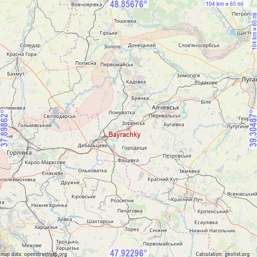
Bayrachky GPS coordinates[2]
48° 23' 31.2" North, 38° 36' 6.264" East
| Map corner | latitude | longitude |
|---|---|---|
| Upper-left | 48.85676°, | 37.89862° |
| Center: | 48.392°, | 38.60174° |
| Lower-right: | 47.92296°, | 39.30487° |
| Map W x H: | 103.8×103.8 km | = 64.5×64.5mi |
| max Lat: | 52.18903° ⇑47.4% North |
| Bayrachky: | 48.392° |
| min Lat: | ⇓52.6% South 44.39214° |
| min Long | Bayrachky | max Long |
| 22.20555° | 38.60174° | 40.13222° |
| W 97.2%⇐ | ⇒2.8% E |
Elevation
Elevation of Bayrachky is 262 m = 860 ft, and this is 106.2 m = 348 ft above average elevation for this country.
| Max E: |
886 m = 2907 ft | 17.1% |
| Bayrachky | 262 m 860 ft | |
| Avg. | 155.8 m = 511 ft | |
Min E: |
-3 m = -10 ft | 82.9% |
See also: Ukraine elevation on elevation.city.
Geographical zone
Bayrachky is located in North temperate zone (between Tropic of Cancer and the Arctic Circle). Distance of this North polar circle is 2020.5 km =1255.5 mi to North.| Distance of | km | miles | from Bayrachky |
|---|---|---|---|
| North Pole | 4626.4 | 2874.7 | to North |
| Arctic Circle | 2020.5 | 1255.5 | to North |
| Tropic Cancer | 2774.8 | 1724.2 | to South |
| Equator | 5380.7 | 3343.4 | to South |


Nearby cities:
15 places around Bayrachky: (largest is in red/bold)
• Alchevs’k
18 km =11.2 mi,  61°
61°
• Artemivs’k
11 km =6.8 mi, 60°
• Bryanka
14.2 km =8.8 mi,  21°
21°
• Chornukhyne
9.6 km =6 mi,  217°
217°
• Debal’tseve
15.6 km =9.7 mi,  248°
248°
• Kadiyivka
19.8 km =12.3 mi,  8°
8°
• Kirovs’k
27.5 km =17.1 mi, 6°
• Krasnyy Kut
25.7 km =16 mi,  145°
145°
• Luhans’ke
25.8 km =16 mi,  283°
283°
• Pereval’s’k
18.6 km =11.6 mi,  74°
74°
• Pervomays’k
26.7 km =16.6 mi,  351°
351°
• Rozsypne
27 km =16.8 mi,  184°
184°
• Svetlodarsk
28.3 km =17.6 mi, 279°
• Vuhlehirs’k
25.7 km =16 mi, 250°
• Zoryns’k
2.7 km =1.7 mi,  36°
36°
Sources, notices
• [Note1] Compared only with cities in Ukraine existing in our database
• [Src1] Map data: © OpenStreetMap contributors (CC-BY-SA)
• [Src2] Other city data from geonames.org with taken over terms of usage.
• [Src3] Geographical zone / Annual Mean Temperature by Robert A. Rohde @ Wikipedia
