Ladan geodata
Ladan (Chernihiv) is a populated place; located in Ukraine in Europe/Kiev (GMT+3) time zone. With population of 6,719 people, there are 528 cities with bigger population in this country. Compared to other cities in Ukraine, 91.2% of cities are located further ↓South; 54.9% of cities are located further →East and 56% of cities have lower elevation than Ladan. Note1


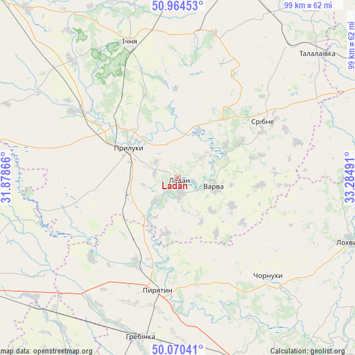
Ladan GPS coordinates[2]
50° 31' 10.524" North, 32° 34' 54.408" East
| Map corner | latitude | longitude |
|---|---|---|
| Upper-left | 50.96453°, | 31.87866° |
| Center: | 50.51959°, | 32.58178° |
| Lower-right: | 50.07041°, | 33.28491° |
| Map W x H: | 99.4×99.4 km | = 61.8×61.8mi |
| max Lat: | 52.18903° ⇑8.8% North |
| Ladan: | 50.51959° |
| min Lat: | ⇓91.2% South 44.39214° |
| min Long | Ladan | max Long |
| 22.20555° | 32.58178° | 40.13222° |
| W 45.1%⇐ | ⇒54.9% E |
Elevation
Elevation of Ladan is 155 m = 509 ft, and this is 0.80000000000001 m = 3 ft below average elevation for this country.
| Max E: |
886 m = 2907 ft | 44% |
| Avg. | 155.8 m = 511 ft | |
| Ladan | 155 m = 509 ft | |
Min E: |
-3 m = -10 ft | 56% |
See also: Ukraine elevation on elevation.city.
Geographical zone
Ladan is located in North temperate zone (between Tropic of Cancer and the Arctic Circle). Distance of this North polar circle is 1783.9 km =1108.5 mi to North.| Distance of | km | miles | from Ladan |
|---|---|---|---|
| North Pole | 4389.8 | 2727.7 | to North |
| Arctic Circle | 1783.9 | 1108.5 | to North |
| Tropic Cancer | 3011.3 | 1871.1 | to South |
| Equator | 5617.3 | 3490.4 | to South |


Nearby cities:
15 places around Ladan: (largest is in red/bold)
• Bogdanivka
52.4 km =32.6 mi,  230°
230°
• Chervone
48.4 km =30.1 mi,  248°
248°
• Chornukhy
37.9 km =23.5 mi,  137°
137°
• Dihtyari
15 km =9.3 mi,  62°
62°
• Druzhba
35.1 km =21.8 mi,  333°
333°
• Hrebinka
45.9 km =28.5 mi,  193°
193°
• Ichnya
40.4 km =25.1 mi,  340°
340°
• Lisovi Sorochyntsi
25.9 km =16.1 mi,  316°
316°
• Lokhvytsya
50.9 km =31.6 mi,  109°
109°
• Lozovyy Yar
46.9 km =29.1 mi,  242°
242°
• Pryluky
16 km =9.9 mi,  300°
300°
• Pyryatyn
31.3 km =19.4 mi, 189°
• Sribne
28.7 km =17.8 mi, 56°
• Varva
10.1 km =6.3 mi, 105°
• Zhuravka
4.4 km =2.7 mi,  167°
167°
Sources, notices
• [Note1] Compared only with cities in Ukraine existing in our database
• [Src1] Map data: © OpenStreetMap contributors (CC-BY-SA)
• [Src2] Other city data from geonames.org with taken over terms of usage.
• [Src3] Geographical zone / Annual Mean Temperature by Robert A. Rohde @ Wikipedia
