Lisovi Sorochyntsi geodata
Lisovi Sorochyntsi (Chernihiv) is a populated place; located in Ukraine in Europe/Kiev (GMT+3) time zone. With population of 4,050 people, there are 755 cities with bigger population in this country. Compared to other cities in Ukraine, 93.3% of cities are located further ↓South; 56.1% of cities are located further →East and 53.5% of cities have lower elevation than Lisovi Sorochyntsi. Note1


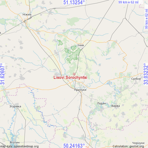
Lisovi Sorochyntsi GPS coordinates[2]
50° 41' 21.12" North, 32° 19' 45.084" East
| Map corner | latitude | longitude |
|---|---|---|
| Upper-left | 51.13254°, | 31.62607° |
| Center: | 50.6892°, | 32.32919° |
| Lower-right: | 50.24163°, | 33.03232° |
| Map W x H: | 99.1×99.1 km | = 61.6×61.6mi |
| max Lat: | 52.18903° ⇑6.7% North |
| Lisovi Sorochyntsi: | 50.6892° |
| min Lat: | ⇓93.3% South 44.39214° |
| min Long | Lisovi Sorochyn | max Long |
| 22.20555° | 32.32919° | 40.13222° |
| W 43.9%⇐ | ⇒56.1% E |
Elevation
Elevation of Lisovi Sorochyntsi is 147 m = 482 ft, and this is 8.8 m = 29 ft below average elevation for this country.
| Max E: |
886 m = 2907 ft | 46.5% |
| Avg. | 155.8 m = 511 ft | |
| Lisovi Sorochyntsi | 147 m = 482 ft | |
Min E: |
-3 m = -10 ft | 53.5% |
See also: Ukraine elevation on elevation.city.
Geographical zone
Lisovi Sorochyntsi is located in North temperate zone (between Tropic of Cancer and the Arctic Circle). Distance of this North polar circle is 1765.1 km =1096.8 mi to North.| Distance of | km | miles | from Lisovi Sorochyntsi |
|---|---|---|---|
| North Pole | 4371 | 2716 | to North |
| Arctic Circle | 1765.1 | 1096.8 | to North |
| Tropic Cancer | 3030.2 | 1882.9 | to South |
| Equator | 5636.1 | 3502.1 | to South |


Nearby cities:
15 places around Lisovi Sorochyntsi: (largest is in red/bold)
• Chervone
45.7 km =28.4 mi,  216°
216°
• Dihtyari
33.3 km =20.7 mi,  110°
110°
• Druzhba
12.7 km =7.9 mi,  9°
9°
• Ichnya
19.8 km =12.3 mi, 13°
• Kruty
44.1 km =27.4 mi,  339°
339°
• Kunashëvka
45 km =28 mi,  330°
330°
• Ladan
25.9 km =16.1 mi,  136°
136°
• Lozovyy Yar
47.1 km =29.3 mi,  209°
209°
• Nizhyn
50.5 km =31.4 mi,  322°
322°
• Pryluky
11.4 km =7.1 mi,  158°
158°
• Sribne
41.6 km =25.8 mi,  93°
93°
• Talalayivka
41.4 km =25.7 mi, 316°
• Varva
35 km =21.7 mi,  128°
128°
• Zgurovka
43.7 km =27.2 mi,  241°
241°
• Zhuravka
29.8 km =18.5 mi, 140°
Sources, notices
• [Note1] Compared only with cities in Ukraine existing in our database
• [Src1] Map data: © OpenStreetMap contributors (CC-BY-SA)
• [Src2] Other city data from geonames.org with taken over terms of usage.
• [Src3] Geographical zone / Annual Mean Temperature by Robert A. Rohde @ Wikipedia
