Chornorudka geodata
Chornorudka (Zhytomyr) is a populated place; located in Ukraine in Europe/Kiev (GMT+3) time zone. With population of 1,005 people, there are 1378 cities with bigger population in this country. Compared to other cities in Ukraine, 80.9% of cities are located further ↓South; 72.3% of cities are located further →East and 78.8% of cities have lower elevation than Chornorudka. Note1


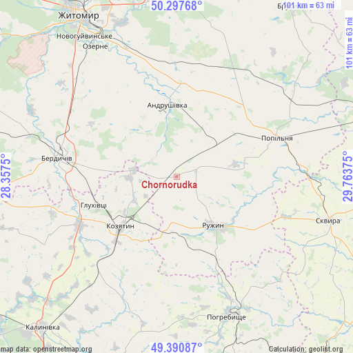
Chornorudka GPS coordinates[2]
49° 50' 47.04" North, 29° 3' 38.232" East
| Map corner | latitude | longitude |
|---|---|---|
| Upper-left | 50.29768°, | 28.3575° |
| Center: | 49.8464°, | 29.06062° |
| Lower-right: | 49.39087°, | 29.76375° |
| Map W x H: | 100.8×100.8 km | = 62.6×62.6mi |
| max Lat: | 52.18903° ⇑19.1% North |
| Chornorudka: | 49.8464° |
| min Lat: | ⇓80.9% South 44.39214° |
| min Long | Chornorudka | max Long |
| 22.20555° | 29.06062° | 40.13222° |
| W 27.7%⇐ | ⇒72.3% E |
Elevation
Elevation of Chornorudka is 241 m = 791 ft, and this is 85.2 m = 280 ft above average elevation for this country.
| Max E: |
886 m = 2907 ft | 21.2% |
| Chornorudka | 241 m 791 ft | |
| Avg. | 155.8 m = 511 ft | |
Min E: |
-3 m = -10 ft | 78.8% |
See also: Ukraine elevation on elevation.city.
Geographical zone
Chornorudka is located in North temperate zone (between Tropic of Cancer and the Arctic Circle). Distance of this North polar circle is 1858.8 km =1155 mi to North.| Distance of | km | miles | from Chornorudka |
|---|---|---|---|
| North Pole | 4464.7 | 2774.2 | to North |
| Arctic Circle | 1858.8 | 1155 | to North |
| Tropic Cancer | 2936.5 | 1824.7 | to South |
| Equator | 5542.4 | 3443.9 | to South |


Nearby cities:
15 places around Chornorudka: (largest is in red/bold)
• Andrushivka
19.8 km =12.3 mi,  351°
351°
• Andrushky
20.7 km =12.9 mi,  78°
78°
• Berdychiv
33.4 km =20.8 mi,  280°
280°
• Brovky Pershi
13.7 km =8.5 mi,  45°
45°
• Bystriivka
14.9 km =9.3 mi,  92°
92°
• Chervone
17.9 km =11.1 mi,  309°
309°
• Derhanivka
17.3 km =10.7 mi,  179°
179°
• Golubivka
19.7 km =12.2 mi,  158°
158°
• Hryshkivtsi
34.2 km =21.3 mi,  286°
286°
• Kozyatyn
21.9 km =13.6 mi,  227°
227°
• Kvitneve
37.2 km =23.1 mi,  64°
64°
• Popilnia
30.5 km =19 mi,  67°
67°
• Ruzhyn
17.2 km =10.7 mi,  143°
143°
• Topory
28.4 km =17.6 mi, 139°
• Zarudyntsi
23.6 km =14.7 mi, 156°
Sources, notices
• [Note1] Compared only with cities in Ukraine existing in our database
• [Src1] Map data: © OpenStreetMap contributors (CC-BY-SA)
• [Src2] Other city data from geonames.org with taken over terms of usage.
• [Src3] Geographical zone / Annual Mean Temperature by Robert A. Rohde @ Wikipedia
