Topory geodata
Topory (Zhytomyr) is a populated place; located in Ukraine in Europe/Kiev (GMT+3) time zone. With population of 1,109 people, there are 1331 cities with bigger population in this country. Compared to other cities in Ukraine, 77% of cities are located further ↓South; 71.1% of cities are located further →East and 74.9% of cities have lower elevation than Topory. Note1


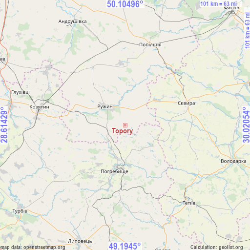
Topory GPS coordinates[2]
49° 39' 6.696" North, 29° 19' 2.676" East
| Map corner | latitude | longitude |
|---|---|---|
| Upper-left | 50.10496°, | 28.61429° |
| Center: | 49.65186°, | 29.31741° |
| Lower-right: | 49.1945°, | 30.02054° |
| Map W x H: | 101.2×101.2 km | = 62.9×62.9mi |
| max Lat: | 52.18903° ⇑23% North |
| Topory: | 49.65186° |
| min Lat: | ⇓77% South 44.39214° |
| min Long | Topory | max Long |
| 22.20555° | 29.31741° | 40.13222° |
| W 28.9%⇐ | ⇒71.1% E |
Elevation
Elevation of Topory is 226 m = 741 ft, and this is 70.2 m = 230 ft above average elevation for this country.
| Max E: |
886 m = 2907 ft | 25.1% |
| Topory | 226 m 741 ft | |
| Avg. | 155.8 m = 511 ft | |
Min E: |
-3 m = -10 ft | 74.9% |
See also: Ukraine elevation on elevation.city.
Geographical zone
Topory is located in North temperate zone (between Tropic of Cancer and the Arctic Circle). Distance of this North polar circle is 1880.4 km =1168.4 mi to North.| Distance of | km | miles | from Topory |
|---|---|---|---|
| North Pole | 4486.3 | 2787.7 | to North |
| Arctic Circle | 1880.4 | 1168.4 | to North |
| Tropic Cancer | 2914.9 | 1811.2 | to South |
| Equator | 5520.8 | 3430.5 | to South |


Nearby cities:
15 places around Topory: (largest is in red/bold)
• Andrushky
25.7 km =16 mi,  4°
4°
• Brovky Pershi
32.3 km =20.1 mi,  344°
344°
• Buky
31.5 km =19.6 mi,  48°
48°
• Bystriivka
21.2 km =13.2 mi,  350°
350°
• Chornorudka
28.4 km =17.6 mi,  319°
319°
• Derhanivka
18.9 km =11.7 mi,  283°
283°
• Golubivka
11.7 km =7.3 mi,  286°
286°
• Kozyatyn
35.5 km =22.1 mi, 281°
• Kvitneve
40.4 km =25.1 mi,  22°
22°
• Pohrebyshche
18.8 km =11.7 mi,  191°
191°
• Popilnia
34.9 km =21.7 mi, 16°
• Ruzhyn
11.3 km =7 mi,  314°
314°
• Skvyra
26.6 km =16.5 mi,  70°
70°
• Tetiiv
39.6 km =24.6 mi,  140°
140°
• Zarudyntsi
9.1 km =5.7 mi,  269°
269°
Sources, notices
• [Note1] Compared only with cities in Ukraine existing in our database
• [Src1] Map data: © OpenStreetMap contributors (CC-BY-SA)
• [Src2] Other city data from geonames.org with taken over terms of usage.
• [Src3] Geographical zone / Annual Mean Temperature by Robert A. Rohde @ Wikipedia
